Taillebourg geodata
Taillebourg (Nouvelle-Aquitaine) is a populated place; located in France in Europe/Paris (GMT+2) time zone. With population of 639 people, there are 12686 cities with bigger population in this country. Compared to other cities in France, 68.7% of cities are located further ↑North; 85% of cities are located further →East and 95.4% of cities have higher elevation than Taillebourg. Note1
Administrative division(s):
- Level 1: Nouvelle-Aquitaine
- Level 2: Charente-Maritime
- Level 3: Arrondissement de Saint-Jean-d'Angély
- Level 4: Taillebourg


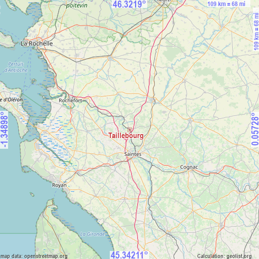
Taillebourg GPS coordinates[2]
45° 50' 2.976" North, 0° 38' 45.06" West
| Map corner | latitude | longitude |
|---|---|---|
| Upper-left | 46.3219°, | -1.34898° |
| Center: | 45.83416°, | -0.64585° |
| Lower-right: | 45.34211°, | 0.05728° |
| Map W x H: | 108.9×108.9 km | = 67.7×67.7mi |
| max Lat: | 51.07786° ⇑68.7% North |
| Taillebourg: | 45.83416° |
| min Lat: | ⇓31.3% South 41.3874° |
| min Long | Taillebourg | max Long |
| -5.08615° | -0.64585° | 9.52242° |
| W 15%⇐ | ⇒85% E |
Elevation
Elevation of Taillebourg is 16 m = 52 ft, and this is 177.7 m = 583 ft below average elevation for this country.
| Max E: |
2333 m = 7654 ft | 95.4% |
| Avg. | 193.7 m = 635 ft | |
| Taillebourg | 16 m = 52 ft | |
Min E: |
-1 m = -3 ft | 4.6% |
See also: France elevation on elevation.city.
Geographical zone
Taillebourg is located in North temperate zone (between Tropic of Cancer and the Arctic Circle). Distance of this North polar circle is 2304.9 km =1432.2 mi to North.| Distance of | km | miles | from Taillebourg |
|---|---|---|---|
| North Pole | 4910.8 | 3051.4 | to North |
| Arctic Circle | 2304.9 | 1432.2 | to North |
| Tropic Cancer | 2490.4 | 1547.5 | to South |
| Equator | 5096.3 | 3166.7 | to South |


Nearby cities:
15 places around Taillebourg: (largest is in red/bold)
• Bussac-sur-Charente
5.7 km =3.5 mi,  170°
170°
• Fontcouverte
8.8 km =5.5 mi,  148°
148°
• Geay
10.1 km =6.3 mi,  294°
294°
• Le Douhet
6.3 km =3.9 mi,  102°
102°
• Les Essards
9.9 km =6.2 mi,  241°
241°
• Les Nouillers
10.9 km =6.8 mi,  352°
352°
• Mazeray
10.4 km =6.5 mi,  37°
37°
• Nieul-lès-Saintes
10.6 km =6.6 mi,  218°
218°
• Plassay
6.4 km =4 mi,  253°
253°
• Saint-Georges-des-Coteaux
9.3 km =5.8 mi, 216°
• Saint-Hilaire-de-Villefranche
9.2 km =5.7 mi,  78°
78°
• Saint-Porchaire
10.7 km =6.6 mi,  261°
261°
• Saint-Savinien
5.4 km =3.4 mi,  331°
331°
• Saintes
9.9 km =6.2 mi, 174°
• Vénérand
8.3 km =5.2 mi,  123°
123°
Sources, notices
• [Note1] Compared only with cities in France existing in our database
• [Src1] Map data: © OpenStreetMap contributors (CC-BY-SA)
• [Src2] Other city data from geonames.org with taken over terms of usage.
• [Src3] Geographical zone / Annual Mean Temperature by Robert A. Rohde @ Wikipedia
