Saintes geodata
Saintes (Nouvelle-Aquitaine) is a seat of a third-order administrative division; located in France in Europe/Paris (GMT+2) time zone. With population of 29,512 people, there are 279 cities with bigger population in this country. Compared to other cities in France, 70.1% of cities are located further ↑North; 84.8% of cities are located further →East and 99.3% of cities have higher elevation than Saintes. Note1
Administrative division(s):
- Level 1: Nouvelle-Aquitaine
- Level 2: Charente-Maritime
- Level 3: Arrondissement de Saintes
- Level 4: Saintes


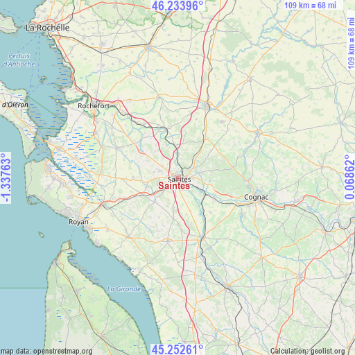
Saintes GPS coordinates[2]
45° 44' 43.584" North, 0° 38' 4.2" West
| Map corner | latitude | longitude |
|---|---|---|
| Upper-left | 46.23396°, | -1.33763° |
| Center: | 45.74544°, | -0.6345° |
| Lower-right: | 45.25261°, | 0.06862° |
| Map W x H: | 109.1×109.1 km | = 67.8×67.8mi |
| max Lat: | 51.07786° ⇑70.1% North |
| Saintes: | 45.74544° |
| min Lat: | ⇓29.9% South 41.3874° |
| min Long | Saintes | max Long |
| -5.08615° | -0.6345° | 9.52242° |
| W 15.2%⇐ | ⇒84.8% E |
Elevation
Elevation of Saintes is 5 m = 16 ft, and this is 188.7 m = 619 ft below average elevation for this country.
| Max E: |
2333 m = 7654 ft | 99.3% |
| Avg. | 193.7 m = 635 ft | |
| Saintes | 5 m = 16 ft | |
Min E: |
-1 m = -3 ft | 0.7% |
See also: France elevation on elevation.city.
Geographical zone
Saintes is located in North temperate zone (between Tropic of Cancer and the Arctic Circle). Distance of this North polar circle is 2314.8 km =1438.3 mi to North.| Distance of | km | miles | from Saintes |
|---|---|---|---|
| North Pole | 4920.6 | 3057.5 | to North |
| Arctic Circle | 2314.8 | 1438.3 | to North |
| Tropic Cancer | 2480.5 | 1541.3 | to South |
| Equator | 5086.4 | 3160.5 | to South |


Nearby cities:
15 places around Saintes: (largest is in red/bold)
• Bussac-sur-Charente
4.2 km =2.6 mi,  1°
1°
• Chaniers
6.7 km =4.2 mi,  116°
116°
• Chermignac
7.3 km =4.5 mi,  204°
204°
• Courcoury
5.7 km =3.5 mi,  130°
130°
• Fontcouverte
4.4 km =2.7 mi,  56°
56°
• La Chapelle-des-Pots
7.4 km =4.6 mi,  77°
77°
• Le Douhet
10 km =6.2 mi,  31°
31°
• Les Gonds
3.8 km =2.4 mi,  155°
155°
• Nieul-lès-Saintes
7.7 km =4.8 mi,  282°
282°
• Pessines
6.7 km =4.2 mi,  252°
252°
• Saint-Georges-des-Coteaux
6.8 km =4.2 mi,  290°
290°
• Taillebourg
9.9 km =6.2 mi,  354°
354°
• Thénac
8.8 km =5.5 mi,  189°
189°
• Varzay
8.7 km =5.4 mi,  239°
239°
• Vénérand
8 km =5 mi,  48°
48°
Sources, notices
• [Note1] Compared only with cities in France existing in our database
• [Src1] Map data: © OpenStreetMap contributors (CC-BY-SA)
• [Src2] Other city data from geonames.org with taken over terms of usage.
• [Src3] Geographical zone / Annual Mean Temperature by Robert A. Rohde @ Wikipedia
