Gignac geodata
Gignac (Occitanie) is a populated place; located in France in Europe/Paris (GMT+2) time zone. With population of 600 people, there are 13316 cities with bigger population in this country. Compared to other cities in France, 79.6% of cities are located further ↑North; 63.6% of cities are located further →East and 79.8% of cities have lower elevation than Gignac. Note1
Administrative division(s):
- Level 1: Occitanie
- Level 2: Lot
- Level 3: Arrondissement de Gourdon
- Level 4: Gignac


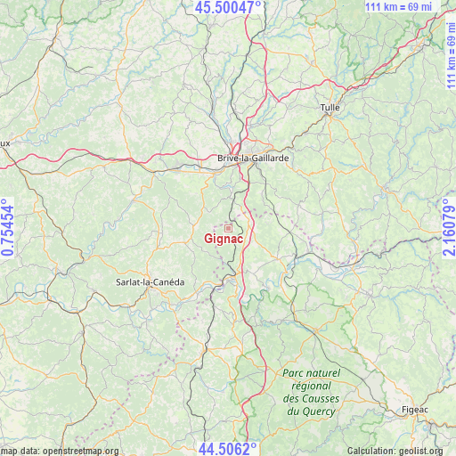
Gignac GPS coordinates[2]
45° 0' 19.764" North, 1° 27' 27.576" East
| Map corner | latitude | longitude |
|---|---|---|
| Upper-left | 45.50047°, | 0.75454° |
| Center: | 45.00549°, | 1.45766° |
| Lower-right: | 44.5062°, | 2.16079° |
| Map W x H: | 110.6×110.6 km | = 68.7×68.7mi |
| max Lat: | 51.07786° ⇑79.6% North |
| Gignac: | 45.00549° |
| min Lat: | ⇓20.4% South 41.3874° |
| min Long | Gignac | max Long |
| -5.08615° | 1.45766° | 9.52242° |
| W 36.4%⇐ | ⇒63.6% E |
Elevation
Elevation of Gignac is 288 m = 945 ft, and this is 94.3 m = 309 ft above average elevation for this country.
| Max E: |
2333 m = 7654 ft | 20.2% |
| Gignac | 288 m 945 ft | |
| Avg. | 193.7 m = 635 ft | |
Min E: |
-1 m = -3 ft | 79.8% |
See also: France elevation on elevation.city.
Geographical zone
Gignac is located in North temperate zone (between Tropic of Cancer and the Arctic Circle). Distance of this North polar circle is 2397 km =1489.4 mi to North.| Distance of | km | miles | from Gignac |
|---|---|---|---|
| North Pole | 5002.9 | 3108.7 | to North |
| Arctic Circle | 2397 | 1489.4 | to North |
| Tropic Cancer | 2398.2 | 1490.2 | to South |
| Equator | 5004.1 | 3109.4 | to South |


Nearby cities:
15 places around Gignac: (largest is in red/bold)
• Chasteaux
9.7 km =6 mi,  4°
4°
• Cressensac
5.3 km =3.3 mi,  69°
69°
• Eyvigues-et-Eybènes
11.7 km =7.3 mi,  226°
226°
• Jugeals-Nazareth
11.6 km =7.2 mi,  43°
43°
• Lachapelle-Auzac
9 km =5.6 mi,  162°
162°
• Larche
13.2 km =8.2 mi,  345°
345°
• Lissac-sur-Couze
11 km =6.8 mi, 1°
• Martel
14.1 km =8.8 mi,  122°
122°
• Nespouls
6.1 km =3.8 mi, 35°
• Noailles
12 km =7.5 mi,  25°
25°
• Pazayac
14.3 km =8.9 mi,  334°
334°
• Salignac-Eyvigues
11 km =6.8 mi,  251°
251°
• Sarrazac
10.4 km =6.5 mi,  82°
82°
• Souillac
12.1 km =7.5 mi,  174°
174°
• Turenne
11.2 km =7 mi,  61°
61°
Sources, notices
• [Note1] Compared only with cities in France existing in our database
• [Src1] Map data: © OpenStreetMap contributors (CC-BY-SA)
• [Src2] Other city data from geonames.org with taken over terms of usage.
• [Src3] Geographical zone / Annual Mean Temperature by Robert A. Rohde @ Wikipedia
