Saint-Fuscien geodata
Saint-Fuscien (Hauts-de-France) is a populated place; located in France in Europe/Paris (GMT+2) time zone. With population of 893 people, there are 9714 cities with bigger population in this country. Compared to other cities in France, 92.5% of cities are located further ↓South; 52.5% of cities are located further →East and 60% of cities have higher elevation than Saint-Fuscien. Note1
Administrative division(s):
- Level 1: Hauts-de-France
- Level 2: Somme
- Level 3: Amiens
- Level 4: Saint-Fuscien


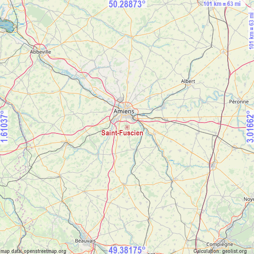
Saint-Fuscien GPS coordinates[2]
49° 50' 14.532" North, 2° 18' 48.564" East
| Map corner | latitude | longitude |
|---|---|---|
| Upper-left | 50.28873°, | 1.61037° |
| Center: | 49.83737°, | 2.31349° |
| Lower-right: | 49.38175°, | 3.01662° |
| Map W x H: | 100.8×100.8 km | = 62.6×62.6mi |
| max Lat: | 51.07786° ⇑7.5% North |
| Saint-Fuscien: | 49.83737° |
| min Lat: | ⇓92.5% South 41.3874° |
| min Long | Saint-Fuscien | max Long |
| -5.08615° | 2.31349° | 9.52242° |
| W 47.5%⇐ | ⇒52.5% E |
Elevation
Elevation of Saint-Fuscien is 102 m = 335 ft, and this is 91.7 m = 301 ft below average elevation for this country.
| Max E: |
2333 m = 7654 ft | 60% |
| Avg. | 193.7 m = 635 ft | |
| Saint-Fuscien | 102 m = 335 ft | |
Min E: |
-1 m = -3 ft | 40% |
See also: France elevation on elevation.city.
Geographical zone
Saint-Fuscien is located in North temperate zone (between Tropic of Cancer and the Arctic Circle). Distance of this North polar circle is 1859.8 km =1155.6 mi to North.| Distance of | km | miles | from Saint-Fuscien |
|---|---|---|---|
| North Pole | 4465.7 | 2774.9 | to North |
| Arctic Circle | 1859.8 | 1155.6 | to North |
| Tropic Cancer | 2935.5 | 1824 | to South |
| Equator | 5541.4 | 3443.3 | to South |


Nearby cities:
15 places around Saint-Fuscien: (largest is in red/bold)
• Amiens
7 km =4.3 mi,  352°
352°
• Bacouel-sur-Selle
6.4 km =4 mi,  262°
262°
• Boves
6 km =3.7 mi,  80°
80°
• Cagny
3.5 km =2.2 mi,  37°
37°
• Camon
6 km =3.7 mi,  21°
21°
• Cottenchy
5.9 km =3.7 mi,  121°
121°
• Dury
3.3 km =2.1 mi,  289°
289°
• Longueau
5.1 km =3.2 mi, 39°
• Pont-de-Metz
6.8 km =4.2 mi,  311°
311°
• Rumigny
4 km =2.5 mi,  216°
216°
• Sains-en-Amiénois
2.3 km =1.4 mi,  170°
170°
• Saint-Sauflieu
6.8 km =4.2 mi, 219°
• Saleux
5.9 km =3.7 mi, 290°
• Salouël
6.2 km =3.9 mi, 305°
• Vers-sur-Selles
5.8 km =3.6 mi,  265°
265°
Sources, notices
• [Note1] Compared only with cities in France existing in our database
• [Src1] Map data: © OpenStreetMap contributors (CC-BY-SA)
• [Src2] Other city data from geonames.org with taken over terms of usage.
• [Src3] Geographical zone / Annual Mean Temperature by Robert A. Rohde @ Wikipedia
