Longueau geodata
Longueau (Hauts-de-France) is a populated place; located in France in Europe/Paris (GMT+2) time zone. With population of 5,180 people, there are 1904 cities with bigger population in this country. Compared to other cities in France, 92.8% of cities are located further ↓South; 51.7% of cities are located further →East and 86.2% of cities have higher elevation than Longueau. Note1
Administrative division(s):
- Level 1: Hauts-de-France
- Level 2: Somme
- Level 3: Amiens
- Level 4: Longueau


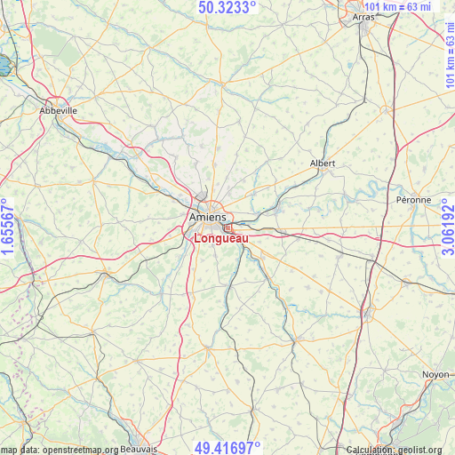
Longueau GPS coordinates[2]
49° 52' 20.136" North, 2° 21' 31.68" East
| Map corner | latitude | longitude |
|---|---|---|
| Upper-left | 50.3233°, | 1.65567° |
| Center: | 49.87226°, | 2.3588° |
| Lower-right: | 49.41697°, | 3.06192° |
| Map W x H: | 100.8×100.8 km | = 62.6×62.6mi |
| max Lat: | 51.07786° ⇑7.2% North |
| Longueau: | 49.87226° |
| min Lat: | ⇓92.8% South 41.3874° |
| min Long | Longueau | max Long |
| -5.08615° | 2.3588° | 9.52242° |
| W 48.3%⇐ | ⇒51.7% E |
Elevation
Elevation of Longueau is 39 m = 128 ft, and this is 154.7 m = 508 ft below average elevation for this country.
| Max E: |
2333 m = 7654 ft | 86.2% |
| Avg. | 193.7 m = 635 ft | |
| Longueau | 39 m = 128 ft | |
Min E: |
-1 m = -3 ft | 13.8% |
See also: France elevation on elevation.city.
Geographical zone
Longueau is located in North temperate zone (between Tropic of Cancer and the Arctic Circle). Distance of this North polar circle is 1855.9 km =1153.2 mi to North.| Distance of | km | miles | from Longueau |
|---|---|---|---|
| North Pole | 4461.8 | 2772.4 | to North |
| Arctic Circle | 1855.9 | 1153.2 | to North |
| Tropic Cancer | 2939.4 | 1826.5 | to South |
| Equator | 5545.3 | 3445.7 | to South |


Nearby cities:
15 places around Longueau: (largest is in red/bold)
• Allonville
7.6 km =4.7 mi,  2°
2°
• Amiens
5.2 km =3.2 mi,  306°
306°
• Blangy-Tronville
4.6 km =2.9 mi,  80°
80°
• Boves
3.9 km =2.4 mi,  137°
137°
• Cagny
1.6 km =1 mi,  225°
225°
• Camon
2 km =1.2 mi,  329°
329°
• Cottenchy
7.2 km =4.5 mi,  165°
165°
• Daours
7.1 km =4.4 mi,  60°
60°
• Dury
6.9 km =4.3 mi,  246°
246°
• Glisy
2.9 km =1.8 mi, 78°
• Rivery
4.3 km =2.7 mi,  322°
322°
• Sains-en-Amiénois
6.8 km =4.2 mi,  205°
205°
• Saint-Fuscien
5.1 km =3.2 mi,  219°
219°
• Salouël
8.3 km =5.2 mi,  268°
268°
• Vecquemont
7.3 km =4.5 mi, 64°
Sources, notices
• [Note1] Compared only with cities in France existing in our database
• [Src1] Map data: © OpenStreetMap contributors (CC-BY-SA)
• [Src2] Other city data from geonames.org with taken over terms of usage.
• [Src3] Geographical zone / Annual Mean Temperature by Robert A. Rohde @ Wikipedia
