Boves geodata
Boves (Hauts-de-France) is a populated place; located in France in Europe/Paris (GMT+2) time zone. With population of 2,826 people, there are 3451 cities with bigger population in this country. Compared to other cities in France, 92.6% of cities are located further ↓South; 51.2% of cities are located further →East and 87.8% of cities have higher elevation than Boves. Note1


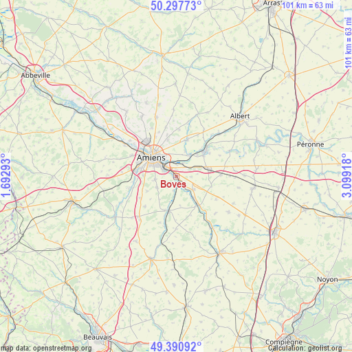
Boves GPS coordinates[2]
49° 50' 47.22" North, 2° 23' 45.78" East
| Map corner | latitude | longitude |
|---|---|---|
| Upper-left | 50.29773°, | 1.69293° |
| Center: | 49.84645°, | 2.39605° |
| Lower-right: | 49.39092°, | 3.09918° |
| Map W x H: | 100.8×100.8 km | = 62.6×62.6mi |
| max Lat: | 51.07786° ⇑7.4% North |
| Boves: | 49.84645° |
| min Lat: | ⇓92.6% South 41.3874° |
| min Long | Boves | max Long |
| -5.08615° | 2.39605° | 9.52242° |
| W 48.8%⇐ | ⇒51.2% E |
Elevation
Elevation of Boves is 35 m = 115 ft, and this is 158.7 m = 521 ft below average elevation for this country.
| Max E: |
2333 m = 7654 ft | 87.8% |
| Avg. | 193.7 m = 635 ft | |
| Boves | 35 m = 115 ft | |
Min E: |
-1 m = -3 ft | 12.2% |
See also: France elevation on elevation.city.
Geographical zone
Boves is located in North temperate zone (between Tropic of Cancer and the Arctic Circle). Distance of this North polar circle is 1858.8 km =1155 mi to North.| Distance of | km | miles | from Boves |
|---|---|---|---|
| North Pole | 4464.7 | 2774.2 | to North |
| Arctic Circle | 1858.8 | 1155 | to North |
| Tropic Cancer | 2936.5 | 1824.7 | to South |
| Equator | 5542.4 | 3443.9 | to South |


Nearby cities:
15 places around Boves: (largest is in red/bold)
• Amiens
9.1 km =5.7 mi,  310°
310°
• Aubigny
8.7 km =5.4 mi,  44°
44°
• Blangy-Tronville
4.1 km =2.5 mi,  27°
27°
• Cagny
4.2 km =2.6 mi,  294°
294°
• Camon
5.9 km =3.7 mi,  321°
321°
• Cottenchy
4.2 km =2.6 mi,  191°
191°
• Daours
7.3 km =4.5 mi, 28°
• Dury
9 km =5.6 mi,  270°
270°
• Glisy
3.5 km =2.2 mi,  2°
2°
• Longueau
3.9 km =2.4 mi, 317°
• Rivery
8.2 km =5.1 mi, 320°
• Sains-en-Amiénois
6.4 km =4 mi,  239°
239°
• Saint-Fuscien
6 km =3.7 mi,  260°
260°
• Vecquemont
7.2 km =4.5 mi, 33°
• Villers-Bretonneux
9 km =5.6 mi,  74°
74°
Sources, notices
• [Note1] Compared only with cities in France existing in our database
• [Src1] Map data: © OpenStreetMap contributors (CC-BY-SA)
• [Src2] Other city data from geonames.org with taken over terms of usage.
• [Src3] Geographical zone / Annual Mean Temperature by Robert A. Rohde @ Wikipedia
