Le Chambon-Feugerolles geodata
Le Chambon-Feugerolles (Auvergne-Rhône-Alpes) is a populated place; located in France in Europe/Paris (GMT+2) time zone. With population of 13,371 people, there are 715 cities with bigger population in this country. Compared to other cities in France, 75.4% of cities are located further ↑North; 70.8% of cities are located further ←West and 95% of cities have lower elevation than Le Chambon-Feugerolles. Note1
Administrative division(s):
- Level 1: Auvergne-Rhône-Alpes
- Level 2: Département de la Loire
- Level 3: Arrondissement de Saint-Étienne
- Level 4: Le Chambon-Feugerolles
Current local time in Le Chambon-Feugerolles:
09:59 AM, SaturdayDifference from your time zone: hours


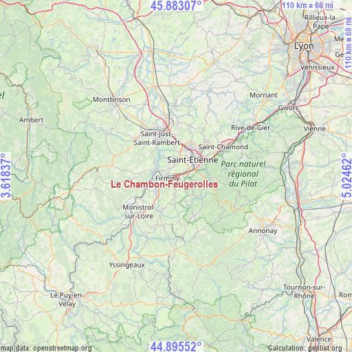
Le Chambon-Feugerolles GPS coordinates[2]
45° 23' 29.22" North, 4° 19' 17.364" East
| Map corner | latitude | longitude |
|---|---|---|
| Upper-left | 45.88307°, | 3.61837° |
| Center: | 45.39145°, | 4.32149° |
| Lower-right: | 44.89552°, | 5.02462° |
| Map W x H: | 109.8×109.8 km | = 68.2×68.2mi |
| max Lat: | 51.07786° ⇑75.4% North |
| Le Chambon-Feugerolles: | 45.39145° |
| min Lat: | ⇓24.6% South 41.3874° |
| min Long | Le Chambon-Feug | max Long |
| -5.08615° | 4.32149° | 9.52242° |
| W 70.8%⇐ | ⇒29.2% E |
Elevation
Elevation of Le Chambon-Feugerolles is 587 m = 1926 ft, and this is 393.3 m = 1290 ft above average elevation for this country.
| Max E: |
2333 m = 7654 ft | 5% |
| Le Chambon-Feugerolles | 587 m 1926 ft | |
| Avg. | 193.7 m = 635 ft | |
Min E: |
-1 m = -3 ft | 95% |
See also: France elevation on elevation.city.
Geographical zone
Le Chambon-Feugerolles is located in North temperate zone (between Tropic of Cancer and the Arctic Circle). Distance of this North polar circle is 2354.1 km =1462.8 mi to North.| Distance of | km | miles | from Le Chambon-Feugerolles |
|---|---|---|---|
| North Pole | 4960 | 3082 | to North |
| Arctic Circle | 2354.1 | 1462.8 | to North |
| Tropic Cancer | 2441.1 | 1516.8 | to South |
| Equator | 5047.1 | 3136.1 | to South |


Nearby cities:
15 places around Le Chambon-Feugerolles: (largest is in red/bold)
• Chambles
9.1 km =5.7 mi,  311°
311°
• Firminy
2.6 km =1.6 mi,  265°
265°
• Fraisses
4.5 km =2.8 mi, 265°
• Jonzieux
9.2 km =5.7 mi,  160°
160°
• La Ricamarie
4.1 km =2.5 mi,  67°
67°
• Pont-Salomon
8.3 km =5.2 mi,  223°
223°
• Roche-la-Molière
4.4 km =2.7 mi,  6°
6°
• Saint-Genest-Lerpt
6 km =3.7 mi, 13°
• Saint-Genest-Malifaux
9.3 km =5.8 mi,  127°
127°
• Saint-Just-Malmont
5.8 km =3.6 mi,  186°
186°
• Saint-Paul
7.5 km =4.7 mi,  275°
275°
• Saint-Romain-les-Atheux
5.2 km =3.2 mi,  122°
122°
• Saint-Étienne
7.1 km =4.4 mi,  48°
48°
• Unieux
4.2 km =2.6 mi,  289°
289°
• Villars
8.9 km =5.5 mi,  17°
17°
Sources, notices
• [Note1] Compared only with cities in France existing in our database
• [Src1] Map data: © OpenStreetMap contributors (CC-BY-SA)
• [Src2] Other city data from geonames.org with taken over terms of usage.
• [Src3] Geographical zone / Annual Mean Temperature by Robert A. Rohde @ Wikipedia
