Sainte-Sigolène geodata
Sainte-Sigolène (Auvergne-Rhône-Alpes) is a populated place; located in France in Europe/Paris (GMT+2) time zone. With population of 5,734 people, there are 1726 cities with bigger population in this country. Compared to other cities in France, 77% of cities are located further ↑North; 70% of cities are located further ←West and 98% of cities have lower elevation than Sainte-Sigolène. Note1
Administrative division(s):
- Level 1: Auvergne-Rhône-Alpes
- Level 2: Haute-Loire
- Level 3: Yssingeaux
- Level 4: Sainte-Sigolène


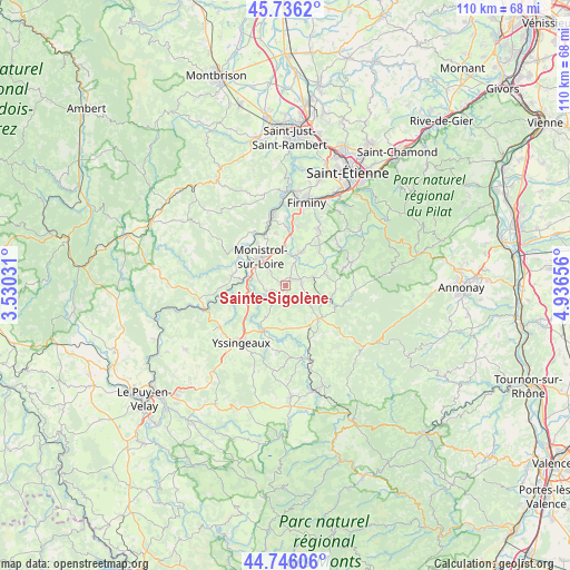
Sainte-Sigolène GPS coordinates[2]
45° 14' 35.844" North, 4° 14' 0.348" East
| Map corner | latitude | longitude |
|---|---|---|
| Upper-left | 45.7362°, | 3.53031° |
| Center: | 45.24329°, | 4.23343° |
| Lower-right: | 44.74606°, | 4.93656° |
| Map W x H: | 110.1×110.1 km | = 68.4×68.4mi |
| max Lat: | 51.07786° ⇑77% North |
| Sainte-Sigolène: | 45.24329° |
| min Lat: | ⇓23% South 41.3874° |
| min Long | Sainte-Sigolèn | max Long |
| -5.08615° | 4.23343° | 9.52242° |
| W 70%⇐ | ⇒30% E |
Elevation
Elevation of Sainte-Sigolène is 818 m = 2684 ft, and this is 624.3 m = 2048 ft above average elevation for this country.
| Max E: |
2333 m = 7654 ft | 2% |
| Sainte-Sigolène | 818 m 2684 ft | |
| Avg. | 193.7 m = 635 ft | |
Min E: |
-1 m = -3 ft | 98% |
See also: France elevation on elevation.city.
Geographical zone
Sainte-Sigolène is located in North temperate zone (between Tropic of Cancer and the Arctic Circle). Distance of this North polar circle is 2370.6 km =1473 mi to North.| Distance of | km | miles | from Sainte-Sigolène |
|---|---|---|---|
| North Pole | 4976.5 | 3092.3 | to North |
| Arctic Circle | 2370.6 | 1473 | to North |
| Tropic Cancer | 2424.7 | 1506.6 | to South |
| Equator | 5030.6 | 3125.9 | to South |


Nearby cities:
15 places around Sainte-Sigolène: (largest is in red/bold)
• Bas-en-Basset
12 km =7.5 mi,  305°
305°
• Beauzac
10.7 km =6.6 mi,  279°
279°
• Dunières
9.2 km =5.7 mi,  109°
109°
• La Séauve-sur-Semène
6 km =3.7 mi,  12°
12°
• Lapte
6.5 km =4 mi,  191°
191°
• Les Villettes
4 km =2.5 mi,  256°
256°
• Monistrol-sur-Loire
7.3 km =4.5 mi,  318°
318°
• Montfaucon-en-Velay
9 km =5.6 mi,  135°
135°
• Pont-Salomon
10.6 km =6.6 mi, 6°
• Raucoules
7.9 km =4.9 mi, 142°
• Saint-Didier-en-Velay
7.4 km =4.6 mi,  26°
26°
• Saint-Maurice-de-Lignon
7.7 km =4.8 mi,  254°
254°
• Saint-Pal-de-Mons
3.2 km =2 mi,  83°
83°
• Saint-Romain-Lachalm
8.3 km =5.2 mi,  72°
72°
• Saint-Victor-Malescours
8.2 km =5.1 mi,  48°
48°
Sources, notices
• [Note1] Compared only with cities in France existing in our database
• [Src1] Map data: © OpenStreetMap contributors (CC-BY-SA)
• [Src2] Other city data from geonames.org with taken over terms of usage.
• [Src3] Geographical zone / Annual Mean Temperature by Robert A. Rohde @ Wikipedia
