Pont-Salomon geodata
Pont-Salomon (Auvergne-Rhône-Alpes) is a populated place; located in France in Europe/Paris (GMT+2) time zone. With population of 1,725 people, there are 5461 cities with bigger population in this country. Compared to other cities in France, 76% of cities are located further ↑North; 70.2% of cities are located further ←West and 97.3% of cities have lower elevation than Pont-Salomon. Note1
Administrative division(s):
- Level 1: Auvergne-Rhône-Alpes
- Level 2: Haute-Loire
- Level 3: Yssingeaux
- Level 4: Pont-Salomon


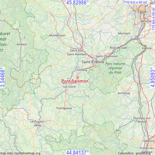
Pont-Salomon GPS coordinates[2]
45° 20' 15.972" North, 4° 14' 52.116" East
| Map corner | latitude | longitude |
|---|---|---|
| Upper-left | 45.82986°, | 3.54468° |
| Center: | 45.33777°, | 4.24781° |
| Lower-right: | 44.84137°, | 4.95093° |
| Map W x H: | 109.9×109.9 km | = 68.3×68.3mi |
| max Lat: | 51.07786° ⇑76% North |
| Pont-Salomon: | 45.33777° |
| min Lat: | ⇓24% South 41.3874° |
| min Long | Pont-Salomon | max Long |
| -5.08615° | 4.24781° | 9.52242° |
| W 70.2%⇐ | ⇒29.8% E |
Elevation
Elevation of Pont-Salomon is 743 m = 2438 ft, and this is 549.3 m = 1802 ft above average elevation for this country.
| Max E: |
2333 m = 7654 ft | 2.7% |
| Pont-Salomon | 743 m 2438 ft | |
| Avg. | 193.7 m = 635 ft | |
Min E: |
-1 m = -3 ft | 97.3% |
See also: France elevation on elevation.city.
Geographical zone
Pont-Salomon is located in North temperate zone (between Tropic of Cancer and the Arctic Circle). Distance of this North polar circle is 2360.1 km =1466.5 mi to North.| Distance of | km | miles | from Pont-Salomon |
|---|---|---|---|
| North Pole | 4966 | 3085.7 | to North |
| Arctic Circle | 2360.1 | 1466.5 | to North |
| Tropic Cancer | 2435.2 | 1513.2 | to South |
| Equator | 5041.1 | 3132.4 | to South |


Nearby cities:
15 places around Pont-Salomon: (largest is in red/bold)
• Aurec-sur-Loire
5 km =3.1 mi,  313°
313°
• Firminy
6.6 km =4.1 mi,  28°
28°
• Fraisses
5.8 km =3.6 mi,  12°
12°
• Jonzieux
9.3 km =5.8 mi,  106°
106°
• La Séauve-sur-Semène
4.7 km =2.9 mi,  177°
177°
• Le Chambon-Feugerolles
8.3 km =5.2 mi,  43°
43°
• Monistrol-sur-Loire
7.7 km =4.8 mi,  229°
229°
• Saint-Didier-en-Velay
4.5 km =2.8 mi,  151°
151°
• Saint-Just-Malmont
5.1 km =3.2 mi,  88°
88°
• Saint-Maurice-en-Gourgois
8.7 km =5.4 mi,  324°
324°
• Saint-Pal-de-Mons
10.4 km =6.5 mi,  168°
168°
• Saint-Paul
7 km =4.3 mi,  345°
345°
• Saint-Romain-Lachalm
10.4 km =6.5 mi,  139°
139°
• Saint-Victor-Malescours
7.2 km =4.5 mi, 135°
• Unieux
7.6 km =4.7 mi, 13°
Sources, notices
• [Note1] Compared only with cities in France existing in our database
• [Src1] Map data: © OpenStreetMap contributors (CC-BY-SA)
• [Src2] Other city data from geonames.org with taken over terms of usage.
• [Src3] Geographical zone / Annual Mean Temperature by Robert A. Rohde @ Wikipedia
