Rennes geodata
Rennes (Brittany) is a seat of a first-order administrative division; located in France in Europe/Paris (GMT+2) time zone. With population of 209,375 people, there are 10 cities with bigger population in this country. Compared to other cities in France, 61.4% of cities are located further ↓South; 93.4% of cities are located further →East and 86.2% of cities have higher elevation than Rennes. Note1
Administrative division(s):
- Level 1: Brittany
- Level 2: Département d'Ille-et-Vilaine
- Level 3: Arrondissement de Rennes
- Level 4: Rennes


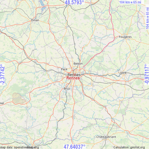
Rennes GPS coordinates[2]
48° 6' 43.128" North, 1° 40' 27.444" West
| Map corner | latitude | longitude |
|---|---|---|
| Upper-left | 48.5793°, | -2.37742° |
| Center: | 48.11198°, | -1.67429° |
| Lower-right: | 47.64037°, | -0.97117° |
| Map W x H: | 104.4×104.4 km | = 64.9×64.9mi |
| max Lat: | 51.07786° ⇑38.6% North |
| Rennes: | 48.11198° |
| min Lat: | ⇓61.4% South 41.3874° |
| min Long | Rennes | max Long |
| -5.08615° | -1.67429° | 9.52242° |
| W 6.6%⇐ | ⇒93.4% E |
Elevation
Elevation of Rennes is 39 m = 128 ft, and this is 154.7 m = 508 ft below average elevation for this country.
| Max E: |
2333 m = 7654 ft | 86.2% |
| Avg. | 193.7 m = 635 ft | |
| Rennes | 39 m = 128 ft | |
Min E: |
-1 m = -3 ft | 13.8% |
See also: Rennes elevation on elevation.city.
Geographical zone
Rennes is located in North temperate zone (between Tropic of Cancer and the Arctic Circle). Distance of this North polar circle is 2051.6 km =1274.8 mi to North.| Distance of | km | miles | from Rennes |
|---|---|---|---|
| North Pole | 4657.5 | 2894 | to North |
| Arctic Circle | 2051.6 | 1274.8 | to North |
| Tropic Cancer | 2743.6 | 1704.8 | to South |
| Equator | 5349.6 | 3324.1 | to South |


Nearby cities:
15 places around Rennes: (largest is in red/bold)
• Acigné
10.5 km =6.5 mi,  76°
76°
• Betton
8.1 km =5 mi,  19°
19°
• Cesson-Sévigné
5.4 km =3.4 mi, 79°
• Chantepie
5.1 km =3.2 mi,  120°
120°
• Chartres-de-Bretagne
8.4 km =5.2 mi,  195°
195°
• Châtillon-sur-Seiche
8.6 km =5.3 mi,  178°
178°
• Fouillard
8.7 km =5.4 mi,  53°
53°
• La Chapelle-des-Fougeretz
8.4 km =5.2 mi,  329°
329°
• Le Rheu
9.2 km =5.7 mi,  263°
263°
• Montgermont
5.7 km =3.5 mi, 328°
• Pacé
8.4 km =5.2 mi,  298°
298°
• Saint-Grégoire
4.4 km =2.7 mi,  347°
347°
• Saint-Jacques-de-la-Lande
6.3 km =3.9 mi,  213°
213°
• Vern-sur-Seiche
9.2 km =5.7 mi,  143°
143°
• Vezin-le-Coquet
6 km =3.7 mi,  277°
277°
Sources, notices
• [Note1] Compared only with cities in France existing in our database
• [Src1] Map data: © OpenStreetMap contributors (CC-BY-SA)
• [Src2] Other city data from geonames.org with taken over terms of usage.
• [Src3] Geographical zone / Annual Mean Temperature by Robert A. Rohde @ Wikipedia
