Chantepie geodata
Chantepie (Brittany) is a populated place; located in France in Europe/Paris (GMT+2) time zone. With population of 7,560 people, there are 1287 cities with bigger population in this country. Compared to other cities in France, 61% of cities are located further ↓South; 93.1% of cities are located further →East and 81.1% of cities have higher elevation than Chantepie. Note1
Administrative division(s):
- Level 1: Brittany
- Level 2: Département d'Ille-et-Vilaine
- Level 3: Arrondissement de Rennes
- Level 4: Chantepie


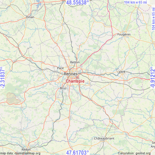
Chantepie GPS coordinates[2]
48° 5' 19.86" North, 1° 36' 54.864" West
| Map corner | latitude | longitude |
|---|---|---|
| Upper-left | 48.55638°, | -2.31837° |
| Center: | 48.08885°, | -1.61524° |
| Lower-right: | 47.61703°, | -0.91212° |
| Map W x H: | 104.4×104.4 km | = 64.9×64.9mi |
| max Lat: | 51.07786° ⇑39% North |
| Chantepie: | 48.08885° |
| min Lat: | ⇓61% South 41.3874° |
| min Long | Chantepie | max Long |
| -5.08615° | -1.61524° | 9.52242° |
| W 6.9%⇐ | ⇒93.1% E |
Elevation
Elevation of Chantepie is 52 m = 171 ft, and this is 141.7 m = 465 ft below average elevation for this country.
| Max E: |
2333 m = 7654 ft | 81.1% |
| Avg. | 193.7 m = 635 ft | |
| Chantepie | 52 m = 171 ft | |
Min E: |
-1 m = -3 ft | 18.9% |
See also: France elevation on elevation.city.
Geographical zone
Chantepie is located in North temperate zone (between Tropic of Cancer and the Arctic Circle). Distance of this North polar circle is 2054.2 km =1276.4 mi to North.| Distance of | km | miles | from Chantepie |
|---|---|---|---|
| North Pole | 4660.1 | 2895.7 | to North |
| Arctic Circle | 2054.2 | 1276.4 | to North |
| Tropic Cancer | 2741.1 | 1703.2 | to South |
| Equator | 5347 | 3322.5 | to South |


Nearby cities:
15 places around Chantepie: (largest is in red/bold)
• Acigné
7.6 km =4.7 mi,  49°
49°
• Brécé
10.2 km =6.3 mi,  77°
77°
• Cesson-Sévigné
3.7 km =2.3 mi,  14°
14°
• Chartres-de-Bretagne
8.7 km =5.4 mi,  230°
230°
• Châteaugiron
9.5 km =5.9 mi,  119°
119°
• Châtillon-sur-Seiche
7.3 km =4.5 mi,  214°
214°
• Fouillard
8.2 km =5.1 mi,  19°
19°
• Nouvoitou
7.3 km =4.5 mi,  136°
136°
• Noyal-sur-Vilaine
7.3 km =4.5 mi,  69°
69°
• Rennes
5.1 km =3.2 mi,  300°
300°
• Saint-Armel
8.6 km =5.3 mi,  168°
168°
• Saint-Erblon
8.2 km =5.1 mi,  199°
199°
• Saint-Grégoire
8.7 km =5.4 mi,  322°
322°
• Saint-Jacques-de-la-Lande
8.3 km =5.2 mi,  251°
251°
• Vern-sur-Seiche
5 km =3.1 mi, 167°
Sources, notices
• [Note1] Compared only with cities in France existing in our database
• [Src1] Map data: © OpenStreetMap contributors (CC-BY-SA)
• [Src2] Other city data from geonames.org with taken over terms of usage.
• [Src3] Geographical zone / Annual Mean Temperature by Robert A. Rohde @ Wikipedia
