Arbin geodata
Arbin (Auvergne-Rhône-Alpes) is a populated place; located in France in Europe/Paris (GMT+2) time zone. With population of 779 people, there are 10831 cities with bigger population in this country. Compared to other cities in France, 74% of cities are located further ↑North; 87.8% of cities are located further ←West and 78.4% of cities have lower elevation than Arbin. Note1
Administrative division(s):
- Level 1: Auvergne-Rhône-Alpes
- Level 2: Savoie
- Level 3: Arrondissement de Chambéry
- Level 4: Arbin


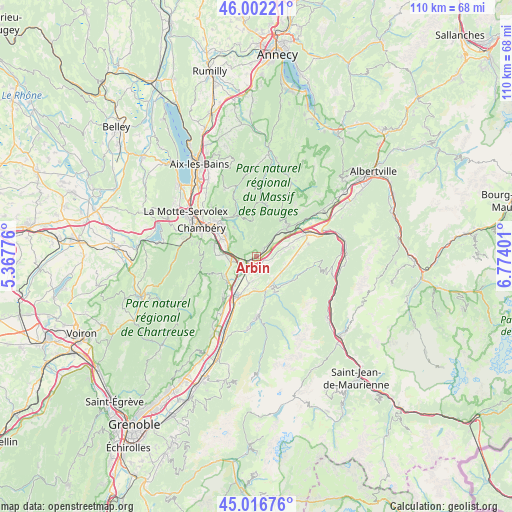
Arbin GPS coordinates[2]
45° 30' 41.904" North, 6° 4' 15.204" East
| Map corner | latitude | longitude |
|---|---|---|
| Upper-left | 46.00221°, | 5.36776° |
| Center: | 45.51164°, | 6.07089° |
| Lower-right: | 45.01676°, | 6.77401° |
| Map W x H: | 109.6×109.6 km | = 68.1×68.1mi |
| max Lat: | 51.07786° ⇑74% North |
| Arbin: | 45.51164° |
| min Lat: | ⇓26% South 41.3874° |
| min Long | Arbin | max Long |
| -5.08615° | 6.07089° | 9.52242° |
| W 87.8%⇐ | ⇒12.2% E |
Elevation
Elevation of Arbin is 275 m = 902 ft, and this is 81.3 m = 267 ft above average elevation for this country.
| Max E: |
2333 m = 7654 ft | 21.6% |
| Arbin | 275 m 902 ft | |
| Avg. | 193.7 m = 635 ft | |
Min E: |
-1 m = -3 ft | 78.4% |
See also: France elevation on elevation.city.
Geographical zone
Arbin is located in North temperate zone (between Tropic of Cancer and the Arctic Circle). Distance of this North polar circle is 2340.8 km =1454.5 mi to North.| Distance of | km | miles | from Arbin |
|---|---|---|---|
| North Pole | 4946.6 | 3073.7 | to North |
| Arctic Circle | 2340.8 | 1454.5 | to North |
| Tropic Cancer | 2454.5 | 1525.2 | to South |
| Equator | 5060.4 | 3144.4 | to South |


Nearby cities:
15 places around Arbin: (largest is in red/bold)
• Challes-les-Eaux
8 km =5 mi,  299°
299°
• Chignin
4.8 km =3 mi,  286°
286°
• Coise
6 km =3.7 mi,  72°
72°
• Cruet
2.5 km =1.6 mi,  40°
40°
• Curienne
7.8 km =4.8 mi,  321°
321°
• Francin
3.2 km =2 mi,  244°
244°
• La Rochette
6.9 km =4.3 mi,  151°
151°
• Laissaud
7.5 km =4.7 mi,  199°
199°
• Les Marches
5.4 km =3.4 mi,  256°
256°
• Les Mollettes
5.5 km =3.4 mi,  190°
190°
• Montmélian
1.3 km =0.8 mi, 237°
• Myans
6 km =3.7 mi,  271°
271°
• Saint-Jean-de-la-Porte
6.7 km =4.2 mi, 42°
• Saint-Jeoire-Prieuré
6.6 km =4.1 mi, 287°
• Sainte-Hélène-du-Lac
3.2 km =2 mi, 187°
Sources, notices
• [Note1] Compared only with cities in France existing in our database
• [Src1] Map data: © OpenStreetMap contributors (CC-BY-SA)
• [Src2] Other city data from geonames.org with taken over terms of usage.
• [Src3] Geographical zone / Annual Mean Temperature by Robert A. Rohde @ Wikipedia
