Larajasse geodata
Larajasse (Auvergne-Rhône-Alpes) is a populated place; located in France in Europe/Paris (GMT+2) time zone. With population of 1,572 people, there are 5929 cities with bigger population in this country. Compared to other cities in France, 72.4% of cities are located further ↑North; 72.1% of cities are located further ←West and 97% of cities have lower elevation than Larajasse. Note1
Administrative division(s):
- Level 1: Auvergne-Rhône-Alpes
- Level 2: Département du Rhône
- Level 3: Arrondissement de Lyon
- Level 4: Larajasse


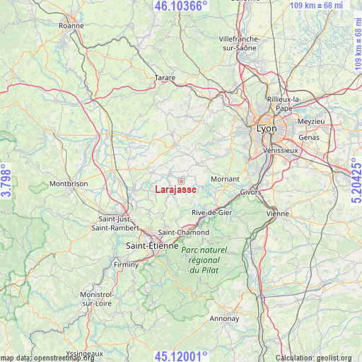
Larajasse GPS coordinates[2]
45° 36' 50.364" North, 4° 30' 4.068" East
| Map corner | latitude | longitude |
|---|---|---|
| Upper-left | 46.10366°, | 3.798° |
| Center: | 45.61399°, | 4.50113° |
| Lower-right: | 45.12001°, | 5.20425° |
| Map W x H: | 109.4×109.4 km | = 68×68mi |
| max Lat: | 51.07786° ⇑72.4% North |
| Larajasse: | 45.61399° |
| min Lat: | ⇓27.6% South 41.3874° |
| min Long | Larajasse | max Long |
| -5.08615° | 4.50113° | 9.52242° |
| W 72.1%⇐ | ⇒27.9% E |
Elevation
Elevation of Larajasse is 724 m = 2375 ft, and this is 530.3 m = 1740 ft above average elevation for this country.
| Max E: |
2333 m = 7654 ft | 3% |
| Larajasse | 724 m 2375 ft | |
| Avg. | 193.7 m = 635 ft | |
Min E: |
-1 m = -3 ft | 97% |
See also: France elevation on elevation.city.
Geographical zone
Larajasse is located in North temperate zone (between Tropic of Cancer and the Arctic Circle). Distance of this North polar circle is 2329.4 km =1447.4 mi to North.| Distance of | km | miles | from Larajasse |
|---|---|---|---|
| North Pole | 4935.3 | 3066.7 | to North |
| Arctic Circle | 2329.4 | 1447.4 | to North |
| Tropic Cancer | 2465.9 | 1532.2 | to South |
| Equator | 5071.8 | 3151.5 | to South |


Nearby cities:
15 places around Larajasse: (largest is in red/bold)
• Aveize
7.8 km =4.8 mi,  346°
346°
• Chevrières
8.2 km =5.1 mi,  250°
250°
• Coise
2.2 km =1.4 mi,  269°
269°
• Duerne
8.1 km =5 mi,  14°
14°
• Grammond
7 km =4.3 mi,  220°
220°
• Grézieu-le-Marché
7.8 km =4.8 mi,  307°
307°
• Marcenod
5 km =3.1 mi,  196°
196°
• Pomeys
6 km =3.7 mi, 311°
• Saint-Christo-en-Jarez
7.7 km =4.8 mi,  187°
187°
• Saint-Denis-sur-Coise
5.9 km =3.7 mi, 270°
• Saint-Didier-sous-Riverie
8.4 km =5.2 mi,  103°
103°
• Saint-Martin-en-Haut
6.9 km =4.3 mi,  42°
42°
• Saint-Romain-en-Jarez
6.7 km =4.2 mi,  156°
156°
• Saint-Symphorien-sur-Coise
4 km =2.5 mi,  300°
300°
• Sainte-Catherine
5.6 km =3.5 mi,  107°
107°
Sources, notices
• [Note1] Compared only with cities in France existing in our database
• [Src1] Map data: © OpenStreetMap contributors (CC-BY-SA)
• [Src2] Other city data from geonames.org with taken over terms of usage.
• [Src3] Geographical zone / Annual Mean Temperature by Robert A. Rohde @ Wikipedia
