Sainte-Blandine geodata
Sainte-Blandine (Nouvelle-Aquitaine) is a populated place; located in France in Europe/Paris (GMT+2) time zone. With population of 557 people, there are 14072 cities with bigger population in this country. Compared to other cities in France, 63% of cities are located further ↑North; 80.6% of cities are located further →East and 68.7% of cities have higher elevation than Sainte-Blandine. Note1
Administrative division(s):
- Level 1: Nouvelle-Aquitaine
- Level 2: Département des Deux-Sèvres
- Level 3: Arrondissement de Niort
- Level 4: Aigondigné


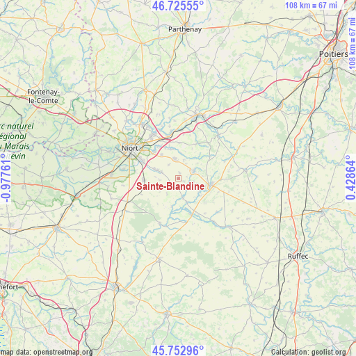
Sainte-Blandine GPS coordinates[2]
46° 14' 29.076" North, 0° 16' 28.128" West
| Map corner | latitude | longitude |
|---|---|---|
| Upper-left | 46.72555°, | -0.97761° |
| Center: | 46.24141°, | -0.27448° |
| Lower-right: | 45.75296°, | 0.42864° |
| Map W x H: | 108.1×108.1 km | = 67.2×67.2mi |
| max Lat: | 51.07786° ⇑63% North |
| Sainte-Blandine: | 46.24141° |
| min Lat: | ⇓37% South 41.3874° |
| min Long | Sainte-Blandine | max Long |
| -5.08615° | -0.27448° | 9.52242° |
| W 19.4%⇐ | ⇒80.6% E |
Elevation
Elevation of Sainte-Blandine is 81 m = 266 ft, and this is 112.7 m = 370 ft below average elevation for this country.
| Max E: |
2333 m = 7654 ft | 68.7% |
| Avg. | 193.7 m = 635 ft | |
| Sainte-Blandine | 81 m = 266 ft | |
Min E: |
-1 m = -3 ft | 31.3% |
See also: France elevation on elevation.city.
Geographical zone
Sainte-Blandine is located in North temperate zone (between Tropic of Cancer and the Arctic Circle). Distance of this North polar circle is 2259.6 km =1404 mi to North.| Distance of | km | miles | from Sainte-Blandine |
|---|---|---|---|
| North Pole | 4865.5 | 3023.3 | to North |
| Arctic Circle | 2259.6 | 1404 | to North |
| Tropic Cancer | 2535.6 | 1575.5 | to South |
| Equator | 5141.6 | 3194.8 | to South |


Nearby cities:
15 places around Sainte-Blandine: (largest is in red/bold)
• Brioux-sur-Boutonne
11.7 km =7.3 mi,  160°
160°
• Brûlain
5.6 km =3.5 mi,  218°
218°
• Celles-sur-Belle
5.3 km =3.3 mi,  64°
64°
• Fors
10.4 km =6.5 mi,  266°
266°
• Melle
10.3 km =6.4 mi,  100°
100°
• Mougon
6.1 km =3.8 mi,  350°
350°
• Prahecq
5.8 km =3.6 mi,  289°
289°
• Prailles
10 km =6.2 mi,  25°
25°
• Périgné
6.2 km =3.9 mi,  166°
166°
• Saint-Martin-de-Bernegoue
5.7 km =3.5 mi, 265°
• Saint-Martin-lès-Melle
8.7 km =5.4 mi, 104°
• Saint-Romans-lès-Melle
7.6 km =4.7 mi,  120°
120°
• Thorigné
5.8 km =3.6 mi,  17°
17°
• Vitré
7.5 km =4.7 mi,  52°
52°
• Vouillé
10.9 km =6.8 mi,  318°
318°
Sources, notices
• [Note1] Compared only with cities in France existing in our database
• [Src1] Map data: © OpenStreetMap contributors (CC-BY-SA)
• [Src2] Other city data from geonames.org with taken over terms of usage.
• [Src3] Geographical zone / Annual Mean Temperature by Robert A. Rohde @ Wikipedia
