Vitré geodata
Vitré (Nouvelle-Aquitaine) is a populated place; located in France in Europe/Paris (GMT+2) time zone. With population of 578 people, there are 13683 cities with bigger population in this country. Compared to other cities in France, 62.5% of cities are located further ↑North; 79.6% of cities are located further →East and 51.7% of cities have higher elevation than Vitré. Note1
Administrative division(s):
- Level 1: Nouvelle-Aquitaine
- Level 2: Département des Deux-Sèvres
- Level 3: Arrondissement de Niort
- Level 4: Beaussais-Vitré


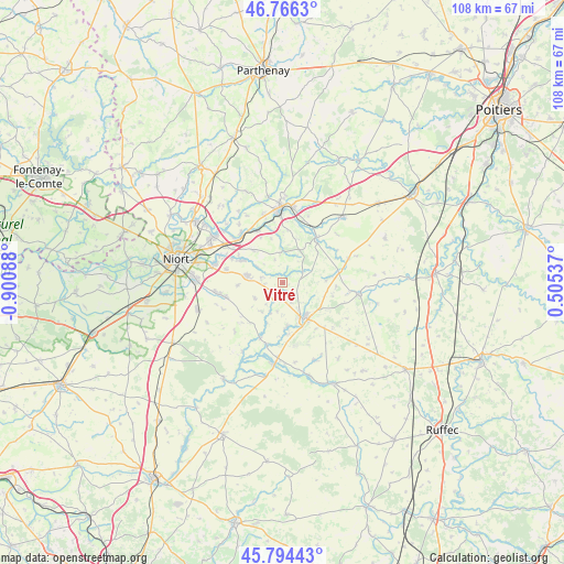
Vitré GPS coordinates[2]
46° 16' 57.072" North, 0° 11' 51.936" West
| Map corner | latitude | longitude |
|---|---|---|
| Upper-left | 46.7663°, | -0.90088° |
| Center: | 46.28252°, | -0.19776° |
| Lower-right: | 45.79443°, | 0.50537° |
| Map W x H: | 108.1×108.1 km | = 67.2×67.2mi |
| max Lat: | 51.07786° ⇑62.5% North |
| Vitré: | 46.28252° |
| min Lat: | ⇓37.5% South 41.3874° |
| min Long | Vitré | max Long |
| -5.08615° | -0.19776° | 9.52242° |
| W 20.4%⇐ | ⇒79.6% E |
Elevation
Elevation of Vitré is 126 m = 413 ft, and this is 67.7 m = 222 ft below average elevation for this country.
| Max E: |
2333 m = 7654 ft | 51.7% |
| Avg. | 193.7 m = 635 ft | |
| Vitré | 126 m = 413 ft | |
Min E: |
-1 m = -3 ft | 48.3% |
See also: France elevation on elevation.city.
Geographical zone
Vitré is located in North temperate zone (between Tropic of Cancer and the Arctic Circle). Distance of this North polar circle is 2255 km =1401.2 mi to North.| Distance of | km | miles | from Vitré |
|---|---|---|---|
| North Pole | 4860.9 | 3020.4 | to North |
| Arctic Circle | 2255 | 1401.2 | to North |
| Tropic Cancer | 2540.2 | 1578.4 | to South |
| Equator | 5146.1 | 3197.6 | to South |


Nearby cities:
15 places around Vitré: (largest is in red/bold)
• Celles-sur-Belle
2.5 km =1.6 mi,  205°
205°
• Chey
11.6 km =7.2 mi,  77°
77°
• Exoudun
11.2 km =7 mi,  52°
52°
• La Mothe-Saint-Héray
10.9 km =6.8 mi,  36°
36°
• Melle
7.7 km =4.8 mi,  147°
147°
• Mougon
7 km =4.3 mi,  281°
281°
• Prahecq
11.7 km =7.3 mi,  257°
257°
• Prailles
4.7 km =2.9 mi,  339°
339°
• Périgné
11.5 km =7.1 mi,  202°
202°
• Romans
8.8 km =5.5 mi, 344°
• Saint-Martin-lès-Melle
7.3 km =4.5 mi,  159°
159°
• Saint-Romans-lès-Melle
8.5 km =5.3 mi,  175°
175°
• Sainte-Blandine
7.5 km =4.7 mi,  232°
232°
• Sainte-Néomaye
11.1 km =6.9 mi,  334°
334°
• Thorigné
4.2 km =2.6 mi, 283°
Sources, notices
• [Note1] Compared only with cities in France existing in our database
• [Src1] Map data: © OpenStreetMap contributors (CC-BY-SA)
• [Src2] Other city data from geonames.org with taken over terms of usage.
• [Src3] Geographical zone / Annual Mean Temperature by Robert A. Rohde @ Wikipedia
