Celles-sur-Belle geodata
Celles-sur-Belle (Nouvelle-Aquitaine) is a populated place; located in France in Europe/Paris (GMT+2) time zone. With population of 3,600 people, there are 2714 cities with bigger population in this country. Compared to other cities in France, 62.8% of cities are located further ↑North; 79.8% of cities are located further →East and 53.8% of cities have higher elevation than Celles-sur-Belle. Note1
Administrative division(s):
- Level 1: Nouvelle-Aquitaine
- Level 2: Département des Deux-Sèvres
- Level 3: Arrondissement de Niort
- Level 4: Celles-sur-Belle


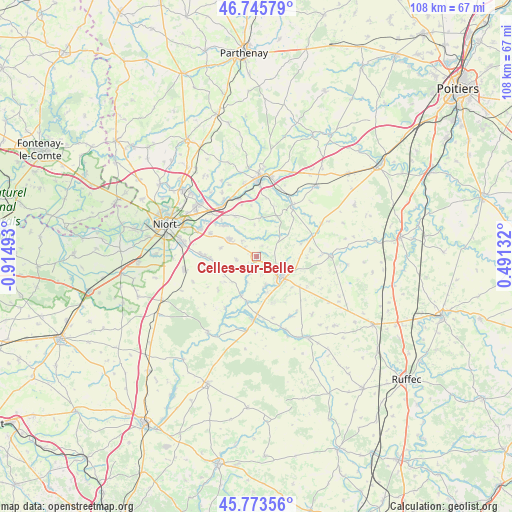
Celles-sur-Belle GPS coordinates[2]
46° 15' 42.588" North, 0° 12' 42.48" West
| Map corner | latitude | longitude |
|---|---|---|
| Upper-left | 46.74579°, | -0.91493° |
| Center: | 46.26183°, | -0.2118° |
| Lower-right: | 45.77356°, | 0.49132° |
| Map W x H: | 108.1×108.1 km | = 67.2×67.2mi |
| max Lat: | 51.07786° ⇑62.8% North |
| Celles-sur-Belle: | 46.26183° |
| min Lat: | ⇓37.2% South 41.3874° |
| min Long | Celles-sur-Bell | max Long |
| -5.08615° | -0.2118° | 9.52242° |
| W 20.2%⇐ | ⇒79.8% E |
Elevation
Elevation of Celles-sur-Belle is 120 m = 394 ft, and this is 73.7 m = 242 ft below average elevation for this country.
| Max E: |
2333 m = 7654 ft | 53.8% |
| Avg. | 193.7 m = 635 ft | |
| Celles-sur-Belle | 120 m = 394 ft | |
Min E: |
-1 m = -3 ft | 46.2% |
See also: France elevation on elevation.city.
Geographical zone
Celles-sur-Belle is located in North temperate zone (between Tropic of Cancer and the Arctic Circle). Distance of this North polar circle is 2257.3 km =1402.6 mi to North.| Distance of | km | miles | from Celles-sur-Belle |
|---|---|---|---|
| North Pole | 4863.2 | 3021.9 | to North |
| Arctic Circle | 2257.3 | 1402.6 | to North |
| Tropic Cancer | 2537.9 | 1577 | to South |
| Equator | 5143.8 | 3196.2 | to South |


Nearby cities:
15 places around Celles-sur-Belle: (largest is in red/bold)
• Brûlain
10.7 km =6.6 mi,  231°
231°
• Chey
13.2 km =8.2 mi,  69°
69°
• Melle
6.7 km =4.2 mi,  128°
128°
• Mougon
6.9 km =4.3 mi,  302°
302°
• Prahecq
10.3 km =6.4 mi,  268°
268°
• Prailles
6.8 km =4.2 mi,  355°
355°
• Périgné
8.9 km =5.5 mi,  201°
201°
• Romans
10.8 km =6.7 mi,  353°
353°
• Saint-Martin-de-Bernegoue
10.9 km =6.8 mi,  255°
255°
• Saint-Martin-lès-Melle
5.8 km =3.6 mi,  141°
141°
• Saint-Romans-lès-Melle
6.4 km =4 mi,  164°
164°
• Sainte-Blandine
5.3 km =3.3 mi,  244°
244°
• Sainte-Néomaye
12.9 km =8 mi,  343°
343°
• Thorigné
4.5 km =2.8 mi,  317°
317°
• Vitré
2.5 km =1.6 mi,  25°
25°
Sources, notices
• [Note1] Compared only with cities in France existing in our database
• [Src1] Map data: © OpenStreetMap contributors (CC-BY-SA)
• [Src2] Other city data from geonames.org with taken over terms of usage.
• [Src3] Geographical zone / Annual Mean Temperature by Robert A. Rohde @ Wikipedia
