Saint-Denis-les-Ponts geodata
Saint-Denis-les-Ponts (Centre) is a populated place; located in France in Europe/Paris (GMT+2) time zone. With population of 1,626 people, there are 5743 cities with bigger population in this country. Compared to other cities in France, 60.6% of cities are located further ↓South; 65.6% of cities are located further →East and 58.7% of cities have higher elevation than Saint-Denis-les-Ponts. Note1
Administrative division(s):
- Level 1: Centre
- Level 2: Département d'Eure-et-Loir
- Level 3: Arrondissement de Châteaudun
- Level 4: Saint-Denis-Lanneray
Current local time in Saint-Denis-les-Ponts:
08:36 AM, SaturdayDifference from your time zone: hours


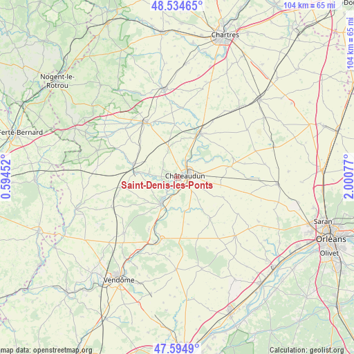
Saint-Denis-les-Ponts GPS coordinates[2]
48° 4' 0.912" North, 1° 17' 51.504" East
| Map corner | latitude | longitude |
|---|---|---|
| Upper-left | 48.53465°, | 0.59452° |
| Center: | 48.06692°, | 1.29764° |
| Lower-right: | 47.5949°, | 2.00077° |
| Map W x H: | 104.5×104.5 km | = 64.9×64.9mi |
| max Lat: | 51.07786° ⇑39.4% North |
| Saint-Denis-les-Ponts: | 48.06692° |
| min Lat: | ⇓60.6% South 41.3874° |
| min Long | Saint-Denis-les | max Long |
| -5.08615° | 1.29764° | 9.52242° |
| W 34.4%⇐ | ⇒65.6% E |
Elevation
Elevation of Saint-Denis-les-Ponts is 106 m = 348 ft, and this is 87.7 m = 288 ft below average elevation for this country.
| Max E: |
2333 m = 7654 ft | 58.7% |
| Avg. | 193.7 m = 635 ft | |
| Saint-Denis-les-Ponts | 106 m = 348 ft | |
Min E: |
-1 m = -3 ft | 41.3% |
See also: France elevation on elevation.city.
Geographical zone
Saint-Denis-les-Ponts is located in North temperate zone (between Tropic of Cancer and the Arctic Circle). Distance of this North polar circle is 2056.6 km =1277.9 mi to North.| Distance of | km | miles | from Saint-Denis-les-Ponts |
|---|---|---|---|
| North Pole | 4662.5 | 2897.1 | to North |
| Arctic Circle | 2056.6 | 1277.9 | to North |
| Tropic Cancer | 2738.6 | 1701.7 | to South |
| Equator | 5344.5 | 3320.9 | to South |


Nearby cities:
15 places around Saint-Denis-les-Ponts: (largest is in red/bold)
• Arrou
13 km =8.1 mi,  285°
285°
• Bonneval
14.5 km =9 mi,  26°
26°
• Châteaudun
3 km =1.9 mi,  81°
81°
• Châtillon-en-Dunois
10 km =6.2 mi,  303°
303°
• Cloyes-sur-le-Loir
9 km =5.6 mi,  210°
210°
• Courtalain
11.8 km =7.3 mi,  277°
277°
• Dangeau
15.7 km =9.8 mi,  356°
356°
• Donnemain-Saint-Mamès
6.9 km =4.3 mi,  50°
50°
• Jallans
5.3 km =3.3 mi, 80°
• La Chapelle-du-Noyer
4 km =2.5 mi,  167°
167°
• Lanneray
4.7 km =2.9 mi, 297°
• Logron
9.2 km =5.7 mi,  344°
344°
• Marboué
5.8 km =3.6 mi, 26°
• Moléans
8.8 km =5.5 mi, 50°
• Saint-Hilaire-sur-Yerre
5.3 km =3.3 mi, 214°
Sources, notices
• [Note1] Compared only with cities in France existing in our database
• [Src1] Map data: © OpenStreetMap contributors (CC-BY-SA)
• [Src2] Other city data from geonames.org with taken over terms of usage.
• [Src3] Geographical zone / Annual Mean Temperature by Robert A. Rohde @ Wikipedia
