Courtalain geodata
Courtalain (Centre) is a populated place; located in France in Europe/Paris (GMT+2) time zone. With population of 581 people, there are 13635 cities with bigger population in this country. Compared to other cities in France, 60.8% of cities are located further ↓South; 67.5% of cities are located further →East and 56.3% of cities have lower elevation than Courtalain. Note1
Administrative division(s):
- Level 1: Centre
- Level 2: Département d'Eure-et-Loir
- Level 3: Arrondissement de Châteaudun
- Level 4: Commune nouvelle d'Arrou


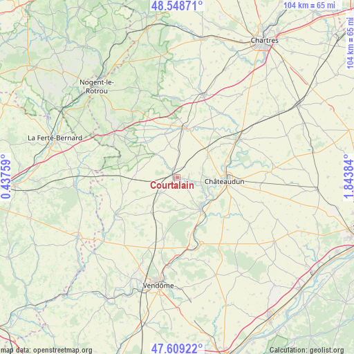
Courtalain GPS coordinates[2]
48° 4' 51.996" North, 1° 8' 26.592" East
| Map corner | latitude | longitude |
|---|---|---|
| Upper-left | 48.54871°, | 0.43759° |
| Center: | 48.08111°, | 1.14072° |
| Lower-right: | 47.60922°, | 1.84384° |
| Map W x H: | 104.5×104.5 km | = 64.9×64.9mi |
| max Lat: | 51.07786° ⇑39.2% North |
| Courtalain: | 48.08111° |
| min Lat: | ⇓60.8% South 41.3874° |
| min Long | Courtalain | max Long |
| -5.08615° | 1.14072° | 9.52242° |
| W 32.5%⇐ | ⇒67.5% E |
Elevation
Elevation of Courtalain is 155 m = 509 ft, and this is 38.7 m = 127 ft below average elevation for this country.
| Max E: |
2333 m = 7654 ft | 43.7% |
| Avg. | 193.7 m = 635 ft | |
| Courtalain | 155 m = 509 ft | |
Min E: |
-1 m = -3 ft | 56.3% |
See also: France elevation on elevation.city.
Geographical zone
Courtalain is located in North temperate zone (between Tropic of Cancer and the Arctic Circle). Distance of this North polar circle is 2055.1 km =1277 mi to North.| Distance of | km | miles | from Courtalain |
|---|---|---|---|
| North Pole | 4660.9 | 2896.1 | to North |
| Arctic Circle | 2055.1 | 1277 | to North |
| Tropic Cancer | 2740.2 | 1702.7 | to South |
| Equator | 5346.1 | 3321.9 | to South |


Nearby cities:
15 places around Courtalain: (largest is in red/bold)
• Arrou
2.1 km =1.3 mi,  333°
333°
• Brou
15.2 km =9.4 mi,  6°
6°
• Châteaudun
14.7 km =9.1 mi,  94°
94°
• Châtillon-en-Dunois
5.2 km =3.2 mi,  40°
40°
• Cloyes-sur-le-Loir
11.8 km =7.3 mi,  142°
142°
• Droué
6.7 km =4.2 mi,  226°
226°
• La Bazoche-Gouet
13.5 km =8.4 mi,  298°
298°
• La Chapelle-du-Noyer
13.7 km =8.5 mi,  113°
113°
• Lanneray
7.5 km =4.7 mi, 85°
• Logron
11.8 km =7.3 mi,  51°
51°
• Marboué
14.7 km =9.1 mi,  75°
75°
• Saint-Denis-les-Ponts
11.8 km =7.3 mi,  97°
97°
• Saint-Hilaire-sur-Yerre
10.5 km =6.5 mi,  124°
124°
• Unverre
13.5 km =8.4 mi,  344°
344°
• Yèvres
14.8 km =9.2 mi, 13°
Sources, notices
• [Note1] Compared only with cities in France existing in our database
• [Src1] Map data: © OpenStreetMap contributors (CC-BY-SA)
• [Src2] Other city data from geonames.org with taken over terms of usage.
• [Src3] Geographical zone / Annual Mean Temperature by Robert A. Rohde @ Wikipedia
