Saint-Cricq-Chalosse geodata
Saint-Cricq-Chalosse (Nouvelle-Aquitaine) is a populated place; located in France in Europe/Paris (GMT+2) time zone. With population of 614 people, there are 13088 cities with bigger population in this country. Compared to other cities in France, 91.2% of cities are located further ↑North; 85.4% of cities are located further →East and 51.7% of cities have higher elevation than Saint-Cricq-Chalosse. Note1
Administrative division(s):
- Level 1: Nouvelle-Aquitaine
- Level 2: Landes
- Level 3: Arrondissement de Mont-de-Marsan
- Level 4: Saint-Cricq-Chalosse


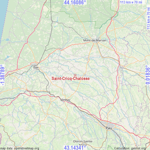
Saint-Cricq-Chalosse GPS coordinates[2]
43° 39' 15.444" North, 0° 41' 5.136" West
| Map corner | latitude | longitude |
|---|---|---|
| Upper-left | 44.16086°, | -1.38789° |
| Center: | 43.65429°, | -0.68476° |
| Lower-right: | 43.14341°, | 0.01836° |
| Map W x H: | 113.1×113.1 km | = 70.3×70.3mi |
| max Lat: | 51.07786° ⇑91.2% North |
| Saint-Cricq-Chalosse: | 43.65429° |
| min Lat: | ⇓8.8% South 41.3874° |
| min Long | Saint-Cricq-Cha | max Long |
| -5.08615° | -0.68476° | 9.52242° |
| W 14.6%⇐ | ⇒85.4% E |
Elevation
Elevation of Saint-Cricq-Chalosse is 126 m = 413 ft, and this is 67.7 m = 222 ft below average elevation for this country.
| Max E: |
2333 m = 7654 ft | 51.7% |
| Avg. | 193.7 m = 635 ft | |
| Saint-Cricq-Chalosse | 126 m = 413 ft | |
Min E: |
-1 m = -3 ft | 48.3% |
See also: France elevation on elevation.city.
Geographical zone
Saint-Cricq-Chalosse is located in North temperate zone (between Tropic of Cancer and the Arctic Circle). Distance of this Northern Tropic circle is 2248 km =1396.8 mi to South.| Distance of | km | miles | from Saint-Cricq-Chalosse |
|---|---|---|---|
| North Pole | 5153.2 | 3202 | to North |
| Arctic Circle | 2547.3 | 1582.8 | to North |
| Tropic Cancer | 2248 | 1396.8 | to South |
| Equator | 4853.9 | 3016.1 | to South |


Nearby cities:
15 places around Saint-Cricq-Chalosse: (largest is in red/bold)
• Amou
8.5 km =5.3 mi,  216°
216°
• Bonnut
13.3 km =8.3 mi,  209°
209°
• Castelnau-Chalosse
12.8 km =8 mi,  274°
274°
• Doazit
5.1 km =3.2 mi,  37°
37°
• Hagetmau
7.5 km =4.7 mi,  86°
86°
• Horsarrieu
7.7 km =4.8 mi,  65°
65°
• Montaut
9.8 km =6.1 mi,  13°
13°
• Montfort-en-Chalosse
14 km =8.7 mi,  296°
296°
• Mugron
11.9 km =7.4 mi,  333°
333°
• Pomarez
12 km =7.5 mi,  256°
256°
• Saint-Sever
14.5 km =9 mi, 37°
• Sainte-Colombe
10.8 km =6.7 mi, 73°
• Sallespisse
13.7 km =8.5 mi,  190°
190°
• Sault-de-Navailles
11.7 km =7.3 mi,  172°
172°
• Tilh
15 km =9.3 mi,  234°
234°
Sources, notices
• [Note1] Compared only with cities in France existing in our database
• [Src1] Map data: © OpenStreetMap contributors (CC-BY-SA)
• [Src2] Other city data from geonames.org with taken over terms of usage.
• [Src3] Geographical zone / Annual Mean Temperature by Robert A. Rohde @ Wikipedia
