Saint-Sever geodata
Saint-Sever (Nouvelle-Aquitaine) is a populated place; located in France in Europe/Paris (GMT+2) time zone. With population of 4,913 people, there are 2016 cities with bigger population in this country. Compared to other cities in France, 89.7% of cities are located further ↑North; 84.2% of cities are located further →East and 59.1% of cities have higher elevation than Saint-Sever. Note1
Administrative division(s):
- Level 1: Nouvelle-Aquitaine
- Level 2: Landes
- Level 3: Arrondissement de Mont-de-Marsan
- Level 4: Saint-Sever


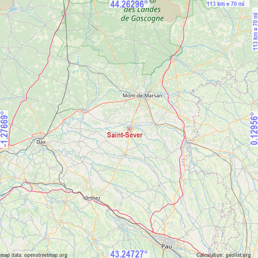
Saint-Sever GPS coordinates[2]
43° 45' 26.172" North, 0° 34' 24.852" West
| Map corner | latitude | longitude |
|---|---|---|
| Upper-left | 44.26296°, | -1.27669° |
| Center: | 43.75727°, | -0.57357° |
| Lower-right: | 43.24727°, | 0.12956° |
| Map W x H: | 112.9×112.9 km | = 70.2×70.2mi |
| max Lat: | 51.07786° ⇑89.7% North |
| Saint-Sever: | 43.75727° |
| min Lat: | ⇓10.3% South 41.3874° |
| min Long | Saint-Sever | max Long |
| -5.08615° | -0.57357° | 9.52242° |
| W 15.8%⇐ | ⇒84.2% E |
Elevation
Elevation of Saint-Sever is 105 m = 344 ft, and this is 88.7 m = 291 ft below average elevation for this country.
| Max E: |
2333 m = 7654 ft | 59.1% |
| Avg. | 193.7 m = 635 ft | |
| Saint-Sever | 105 m = 344 ft | |
Min E: |
-1 m = -3 ft | 40.9% |
See also: France elevation on elevation.city.
Geographical zone
Saint-Sever is located in North temperate zone (between Tropic of Cancer and the Arctic Circle). Distance of this Northern Tropic circle is 2259.4 km =1403.9 mi to South.| Distance of | km | miles | from Saint-Sever |
|---|---|---|---|
| North Pole | 5141.7 | 3194.9 | to North |
| Arctic Circle | 2535.8 | 1575.7 | to North |
| Tropic Cancer | 2259.4 | 1403.9 | to South |
| Equator | 4865.4 | 3023.2 | to South |


Nearby cities:
15 places around Saint-Sever: (largest is in red/bold)
• Aurice
6.8 km =4.2 mi,  338°
338°
• Benquet
10 km =6.2 mi,  35°
35°
• Doazit
9.4 km =5.8 mi,  218°
218°
• Grenade-sur-l’Adour
11.8 km =7.3 mi,  78°
78°
• Hagetmau
11 km =6.8 mi,  187°
187°
• Haut-Mauco
7.9 km =4.9 mi,  10°
10°
• Horsarrieu
8.5 km =5.3 mi, 193°
• Larrivière-Saint-Savin
12.6 km =7.8 mi,  85°
85°
• Montaut
6.8 km =4.2 mi,  253°
253°
• Montgaillard
7.4 km =4.6 mi,  102°
102°
• Montsoué
5.9 km =3.7 mi,  117°
117°
• Saint-Maurice-sur-Adour
9.1 km =5.7 mi,  70°
70°
• Saint-Perdon
12.1 km =7.5 mi,  353°
353°
• Sainte-Colombe
8.5 km =5.3 mi,  170°
170°
• Souprosse
11.5 km =7.1 mi,  287°
287°
Sources, notices
• [Note1] Compared only with cities in France existing in our database
• [Src1] Map data: © OpenStreetMap contributors (CC-BY-SA)
• [Src2] Other city data from geonames.org with taken over terms of usage.
• [Src3] Geographical zone / Annual Mean Temperature by Robert A. Rohde @ Wikipedia
