Mugron geodata
Mugron (Nouvelle-Aquitaine) is a populated place; located in France in Europe/Paris (GMT+2) time zone. With population of 1,493 people, there are 6213 cities with bigger population in this country. Compared to other cities in France, 89.7% of cities are located further ↑North; 86% of cities are located further →East and 68.3% of cities have higher elevation than Mugron. Note1
Administrative division(s):
- Level 1: Nouvelle-Aquitaine
- Level 2: Landes
- Level 3: Arrondissement de Dax
- Level 4: Mugron


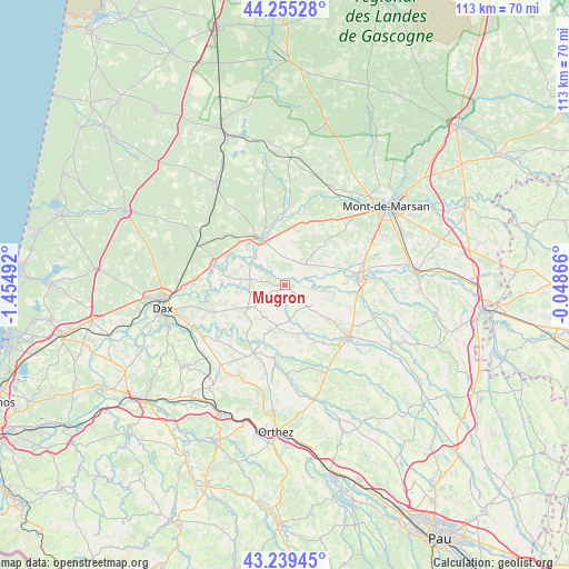
Mugron GPS coordinates[2]
43° 44' 58.272" North, 0° 45' 6.444" West
| Map corner | latitude | longitude |
|---|---|---|
| Upper-left | 44.25528°, | -1.45492° |
| Center: | 43.74952°, | -0.75179° |
| Lower-right: | 43.23945°, | -0.04866° |
| Map W x H: | 112.9×112.9 km | = 70.2×70.2mi |
| max Lat: | 51.07786° ⇑89.7% North |
| Mugron: | 43.74952° |
| min Lat: | ⇓10.3% South 41.3874° |
| min Long | Mugron | max Long |
| -5.08615° | -0.75179° | 9.52242° |
| W 14%⇐ | ⇒86% E |
Elevation
Elevation of Mugron is 82 m = 269 ft, and this is 111.7 m = 366 ft below average elevation for this country.
| Max E: |
2333 m = 7654 ft | 68.3% |
| Avg. | 193.7 m = 635 ft | |
| Mugron | 82 m = 269 ft | |
Min E: |
-1 m = -3 ft | 31.7% |
See also: France elevation on elevation.city.
Geographical zone
Mugron is located in North temperate zone (between Tropic of Cancer and the Arctic Circle). Distance of this Northern Tropic circle is 2258.6 km =1403.4 mi to South.| Distance of | km | miles | from Mugron |
|---|---|---|---|
| North Pole | 5142.6 | 3195.5 | to North |
| Arctic Circle | 2536.7 | 1576.2 | to North |
| Tropic Cancer | 2258.6 | 1403.4 | to South |
| Equator | 4864.5 | 3022.7 | to South |


Nearby cities:
15 places around Mugron: (largest is in red/bold)
• Aurice
13.9 km =8.6 mi,  58°
58°
• Bégaar
11.4 km =7.1 mi,  316°
316°
• Castelnau-Chalosse
12 km =7.5 mi,  217°
217°
• Doazit
10.7 km =6.6 mi,  127°
127°
• Gamarde-les-Bains
9.9 km =6.2 mi,  259°
259°
• Horsarrieu
14.4 km =8.9 mi,  120°
120°
• Meilhan
13.3 km =8.3 mi,  16°
16°
• Montaut
7.8 km =4.8 mi,  97°
97°
• Montfort-en-Chalosse
8.2 km =5.1 mi,  238°
238°
• Poyanne
5.3 km =3.3 mi,  278°
278°
• Poyartin
11.7 km =7.3 mi,  232°
232°
• Saint-Cricq-Chalosse
11.9 km =7.4 mi,  153°
153°
• Saint-Sever
14.3 km =8.9 mi,  86°
86°
• Souprosse
5.5 km =3.4 mi,  37°
37°
• Tartas
10.3 km =6.4 mi,  333°
333°
Sources, notices
• [Note1] Compared only with cities in France existing in our database
• [Src1] Map data: © OpenStreetMap contributors (CC-BY-SA)
• [Src2] Other city data from geonames.org with taken over terms of usage.
• [Src3] Geographical zone / Annual Mean Temperature by Robert A. Rohde @ Wikipedia
