Doazit geodata
Doazit (Nouvelle-Aquitaine) is a populated place; located in France in Europe/Paris (GMT+2) time zone. With population of 922 people, there are 9460 cities with bigger population in this country. Compared to other cities in France, 90.6% of cities are located further ↑North; 85% of cities are located further →East and 57.3% of cities have higher elevation than Doazit. Note1
Administrative division(s):
- Level 1: Nouvelle-Aquitaine
- Level 2: Landes
- Level 3: Arrondissement de Dax
- Level 4: Doazit


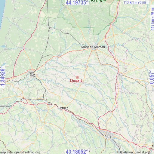
Doazit GPS coordinates[2]
43° 41' 27.924" North, 0° 38' 46.068" West
| Map corner | latitude | longitude |
|---|---|---|
| Upper-left | 44.19735°, | -1.34926° |
| Center: | 43.69109°, | -0.64613° |
| Lower-right: | 43.18052°, | 0.057° |
| Map W x H: | 113.1×113.1 km | = 70.3×70.3mi |
| max Lat: | 51.07786° ⇑90.6% North |
| Doazit: | 43.69109° |
| min Lat: | ⇓9.4% South 41.3874° |
| min Long | Doazit | max Long |
| -5.08615° | -0.64613° | 9.52242° |
| W 15%⇐ | ⇒85% E |
Elevation
Elevation of Doazit is 110 m = 361 ft, and this is 83.7 m = 275 ft below average elevation for this country.
| Max E: |
2333 m = 7654 ft | 57.3% |
| Avg. | 193.7 m = 635 ft | |
| Doazit | 110 m = 361 ft | |
Min E: |
-1 m = -3 ft | 42.7% |
See also: France elevation on elevation.city.
Geographical zone
Doazit is located in North temperate zone (between Tropic of Cancer and the Arctic Circle). Distance of this Northern Tropic circle is 2252.1 km =1399.4 mi to South.| Distance of | km | miles | from Doazit |
|---|---|---|---|
| North Pole | 5149.1 | 3199.5 | to North |
| Arctic Circle | 2543.2 | 1580.3 | to North |
| Tropic Cancer | 2252.1 | 1399.4 | to South |
| Equator | 4858 | 3018.6 | to South |


Nearby cities:
15 places around Doazit: (largest is in red/bold)
• Amou
13.6 km =8.5 mi,  216°
216°
• Aurice
14.1 km =8.8 mi,  13°
13°
• Hagetmau
5.7 km =3.5 mi,  129°
129°
• Horsarrieu
4 km =2.5 mi,  102°
102°
• Montaut
5.5 km =3.4 mi,  352°
352°
• Montfort-en-Chalosse
15.7 km =9.8 mi,  278°
278°
• Montgaillard
14.3 km =8.9 mi,  66°
66°
• Montsoué
12 km =7.5 mi, 67°
• Mugron
10.7 km =6.6 mi,  307°
307°
• Poyanne
15.5 km =9.6 mi,  297°
297°
• Saint-Cricq-Chalosse
5.1 km =3.2 mi, 217°
• Saint-Sever
9.4 km =5.8 mi,  38°
38°
• Sainte-Colombe
7.3 km =4.5 mi, 97°
• Samadet
14.1 km =8.8 mi,  115°
115°
• Souprosse
12 km =7.5 mi,  334°
334°
Sources, notices
• [Note1] Compared only with cities in France existing in our database
• [Src1] Map data: © OpenStreetMap contributors (CC-BY-SA)
• [Src2] Other city data from geonames.org with taken over terms of usage.
• [Src3] Geographical zone / Annual Mean Temperature by Robert A. Rohde @ Wikipedia
