Saint-Claude-de-Diray geodata
Saint-Claude-de-Diray (Centre) is a populated place; located in France in Europe/Paris (GMT+2) time zone. With population of 1,637 people, there are 5706 cities with bigger population in this country. Compared to other cities in France, 52.9% of cities are located further ↓South; 64% of cities are located further →East and 67.4% of cities have higher elevation than Saint-Claude-de-Diray. Note1
Administrative division(s):
- Level 1: Centre
- Level 2: Département du Loir-et-Cher
- Level 3: Arrondissement de Blois
- Level 4: Saint-Claude-de-Diray
Current local time in Saint-Claude-de-Diray:
06:04 AM, SaturdayDifference from your time zone: hours


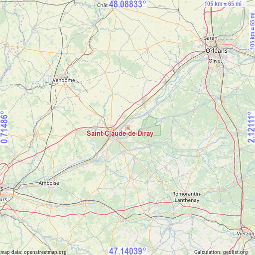
Saint-Claude-de-Diray GPS coordinates[2]
47° 36' 59.436" North, 1° 25' 4.728" East
| Map corner | latitude | longitude |
|---|---|---|
| Upper-left | 48.08833°, | 0.71486° |
| Center: | 47.61651°, | 1.41798° |
| Lower-right: | 47.14039°, | 2.12111° |
| Map W x H: | 105.4×105.4 km | = 65.5×65.5mi |
| max Lat: | 51.07786° ⇑47.1% North |
| Saint-Claude-de-Diray: | 47.61651° |
| min Lat: | ⇓52.9% South 41.3874° |
| min Long | Saint-Claude-de | max Long |
| -5.08615° | 1.41798° | 9.52242° |
| W 36%⇐ | ⇒64% E |
Elevation
Elevation of Saint-Claude-de-Diray is 84 m = 276 ft, and this is 109.7 m = 360 ft below average elevation for this country.
| Max E: |
2333 m = 7654 ft | 67.4% |
| Avg. | 193.7 m = 635 ft | |
| Saint-Claude-de-Diray | 84 m = 276 ft | |
Min E: |
-1 m = -3 ft | 32.6% |
See also: France elevation on elevation.city.
Geographical zone
Saint-Claude-de-Diray is located in North temperate zone (between Tropic of Cancer and the Arctic Circle). Distance of this North polar circle is 2106.7 km =1309 mi to North.| Distance of | km | miles | from Saint-Claude-de-Diray |
|---|---|---|---|
| North Pole | 4712.6 | 2928.3 | to North |
| Arctic Circle | 2106.7 | 1309 | to North |
| Tropic Cancer | 2688.5 | 1670.6 | to South |
| Equator | 5294.5 | 3289.8 | to South |


Nearby cities:
15 places around Saint-Claude-de-Diray: (largest is in red/bold)
• Blois
7.1 km =4.4 mi,  249°
249°
• Huisseau-sur-Cosson
3.7 km =2.3 mi,  134°
134°
• La Chaussée-Saint-Victor
3.8 km =2.4 mi,  269°
269°
• Marolles
9.1 km =5.7 mi,  292°
292°
• Maslives
5 km =3.1 mi,  67°
67°
• Menars
3 km =1.9 mi,  345°
345°
• Mont-près-Chambord
6.7 km =4.2 mi,  154°
154°
• Montlivault
3.3 km =2.1 mi,  37°
37°
• Saint-Denis-sur-Loire
2.5 km =1.6 mi, 291°
• Saint-Dyé-sur-Loire
6.9 km =4.3 mi,  50°
50°
• Saint-Gervais-la-Forêt
7.3 km =4.5 mi,  220°
220°
• Suèvres
6.4 km =4 mi,  30°
30°
• Villebarou
7.2 km =4.5 mi,  276°
276°
• Villerbon
6.2 km =3.9 mi,  326°
326°
• Vineuil
4.8 km =3 mi, 220°
Sources, notices
• [Note1] Compared only with cities in France existing in our database
• [Src1] Map data: © OpenStreetMap contributors (CC-BY-SA)
• [Src2] Other city data from geonames.org with taken over terms of usage.
• [Src3] Geographical zone / Annual Mean Temperature by Robert A. Rohde @ Wikipedia
