Menars geodata
Menars (Centre) is a populated place; located in France in Europe/Paris (GMT+2) time zone. With population of 606 people, there are 13224 cities with bigger population in this country. Compared to other cities in France, 53.3% of cities are located further ↓South; 64.2% of cities are located further →East and 64% of cities have higher elevation than Menars. Note1
Administrative division(s):
- Level 1: Centre
- Level 2: Département du Loir-et-Cher
- Level 3: Arrondissement de Blois
- Level 4: Menars


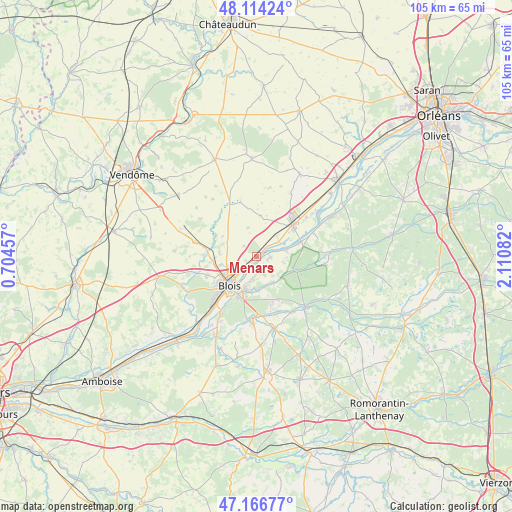
Menars GPS coordinates[2]
47° 38' 33.54" North, 1° 24' 27.72" East
| Map corner | latitude | longitude |
|---|---|---|
| Upper-left | 48.11424°, | 0.70457° |
| Center: | 47.64265°, | 1.4077° |
| Lower-right: | 47.16677°, | 2.11082° |
| Map W x H: | 105.3×105.3 km | = 65.4×65.4mi |
| max Lat: | 51.07786° ⇑46.7% North |
| Menars: | 47.64265° |
| min Lat: | ⇓53.3% South 41.3874° |
| min Long | Menars | max Long |
| -5.08615° | 1.4077° | 9.52242° |
| W 35.8%⇐ | ⇒64.2% E |
Elevation
Elevation of Menars is 92 m = 302 ft, and this is 101.7 m = 334 ft below average elevation for this country.
| Max E: |
2333 m = 7654 ft | 64% |
| Avg. | 193.7 m = 635 ft | |
| Menars | 92 m = 302 ft | |
Min E: |
-1 m = -3 ft | 36% |
See also: France elevation on elevation.city.
Geographical zone
Menars is located in North temperate zone (between Tropic of Cancer and the Arctic Circle). Distance of this North polar circle is 2103.8 km =1307.2 mi to North.| Distance of | km | miles | from Menars |
|---|---|---|---|
| North Pole | 4709.7 | 2926.5 | to North |
| Arctic Circle | 2103.8 | 1307.2 | to North |
| Tropic Cancer | 2691.4 | 1672.4 | to South |
| Equator | 5297.4 | 3291.7 | to South |


Nearby cities:
15 places around Menars: (largest is in red/bold)
• Blois
8 km =5 mi,  227°
227°
• Huisseau-sur-Cosson
6.5 km =4 mi,  148°
148°
• La Chapelle-Saint-Martin-en-Plaine
8.3 km =5.2 mi,  4°
4°
• La Chaussée-Saint-Victor
4.2 km =2.6 mi, 225°
• Marolles
7.6 km =4.7 mi,  274°
274°
• Maslives
5.5 km =3.4 mi,  100°
100°
• Montlivault
2.8 km =1.7 mi, 96°
• Saint-Claude-de-Diray
3 km =1.9 mi,  165°
165°
• Saint-Denis-sur-Loire
2.5 km =1.6 mi,  217°
217°
• Saint-Dyé-sur-Loire
6.2 km =3.9 mi,  76°
76°
• Saint-Gervais-la-Forêt
9.3 km =5.8 mi,  205°
205°
• Suèvres
4.8 km =3 mi,  56°
56°
• Villebarou
6.7 km =4.2 mi,  251°
251°
• Villerbon
3.5 km =2.2 mi,  309°
309°
• Vineuil
7 km =4.3 mi,  199°
199°
Sources, notices
• [Note1] Compared only with cities in France existing in our database
• [Src1] Map data: © OpenStreetMap contributors (CC-BY-SA)
• [Src2] Other city data from geonames.org with taken over terms of usage.
• [Src3] Geographical zone / Annual Mean Temperature by Robert A. Rohde @ Wikipedia
