Villerbon geodata
Villerbon (Centre) is a populated place; located in France in Europe/Paris (GMT+2) time zone. With population of 763 people, there are 11026 cities with bigger population in this country. Compared to other cities in France, 53.7% of cities are located further ↓South; 64.7% of cities are located further →East and 57.6% of cities have higher elevation than Villerbon. Note1
Administrative division(s):
- Level 1: Centre
- Level 2: Département du Loir-et-Cher
- Level 3: Arrondissement de Blois
- Level 4: Villerbon


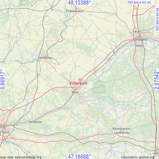
Villerbon GPS coordinates[2]
47° 39' 45.288" North, 1° 22' 20.244" East
| Map corner | latitude | longitude |
|---|---|---|
| Upper-left | 48.13398°, | 0.66917° |
| Center: | 47.66258°, | 1.37229° |
| Lower-right: | 47.18688°, | 2.07542° |
| Map W x H: | 105.3×105.3 km | = 65.4×65.4mi |
| max Lat: | 51.07786° ⇑46.3% North |
| Villerbon: | 47.66258° |
| min Lat: | ⇓53.7% South 41.3874° |
| min Long | Villerbon | max Long |
| -5.08615° | 1.37229° | 9.52242° |
| W 35.3%⇐ | ⇒64.7% E |
Elevation
Elevation of Villerbon is 109 m = 358 ft, and this is 84.7 m = 278 ft below average elevation for this country.
| Max E: |
2333 m = 7654 ft | 57.6% |
| Avg. | 193.7 m = 635 ft | |
| Villerbon | 109 m = 358 ft | |
Min E: |
-1 m = -3 ft | 42.4% |
See also: France elevation on elevation.city.
Geographical zone
Villerbon is located in North temperate zone (between Tropic of Cancer and the Arctic Circle). Distance of this North polar circle is 2101.6 km =1305.9 mi to North.| Distance of | km | miles | from Villerbon |
|---|---|---|---|
| North Pole | 4707.5 | 2925.1 | to North |
| Arctic Circle | 2101.6 | 1305.9 | to North |
| Tropic Cancer | 2693.7 | 1673.8 | to South |
| Equator | 5299.6 | 3293 | to South |


Nearby cities:
15 places around Villerbon: (largest is in red/bold)
• Averdon
6.3 km =3.9 mi,  292°
292°
• Blois
8.3 km =5.2 mi,  203°
203°
• Fossé
7.4 km =4.6 mi,  243°
243°
• La Chapelle-Saint-Martin-en-Plaine
6.9 km =4.3 mi,  28°
28°
• La Chaussée-Saint-Victor
5.2 km =3.2 mi,  183°
183°
• Marolles
5.2 km =3.2 mi,  251°
251°
• Maslives
8.6 km =5.3 mi,  112°
112°
• Menars
3.5 km =2.2 mi,  129°
129°
• Montlivault
6 km =3.7 mi, 114°
• Saint-Claude-de-Diray
6.2 km =3.9 mi,  146°
146°
• Saint-Denis-sur-Loire
4.4 km =2.7 mi,  164°
164°
• Saint-Dyé-sur-Loire
8.7 km =5.4 mi,  94°
94°
• Suèvres
6.7 km =4.2 mi, 86°
• Villebarou
5.7 km =3.5 mi,  220°
220°
• Vineuil
8.8 km =5.5 mi, 178°
Sources, notices
• [Note1] Compared only with cities in France existing in our database
• [Src1] Map data: © OpenStreetMap contributors (CC-BY-SA)
• [Src2] Other city data from geonames.org with taken over terms of usage.
• [Src3] Geographical zone / Annual Mean Temperature by Robert A. Rohde @ Wikipedia
