Saint-Christophe-du-Bois geodata
Saint-Christophe-du-Bois (Pays de la Loire) is a populated place; located in France in Europe/Paris (GMT+2) time zone. With population of 2,667 people, there are 3661 cities with bigger population in this country. Compared to other cities in France, 55% of cities are located further ↑North; 87.7% of cities are located further →East and 66.6% of cities have higher elevation than Saint-Christophe-du-Bois. Note1
Administrative division(s):
- Level 1: Pays de la Loire
- Level 2: Département de Maine-et-Loire
- Level 3: Arrondissement de Cholet
- Level 4: Saint-Christophe-du-Bois
Current local time in Saint-Christophe-du-Bois:
08:37 AM, SaturdayDifference from your time zone: hours


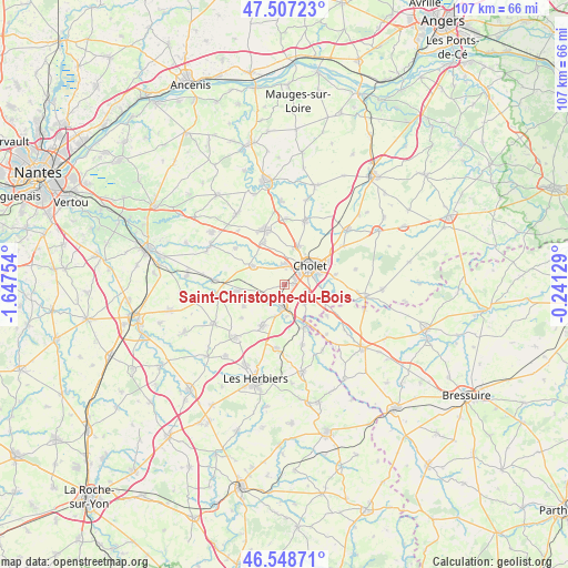
Saint-Christophe-du-Bois GPS coordinates[2]
47° 1' 48.432" North, 0° 56' 39.876" West
| Map corner | latitude | longitude |
|---|---|---|
| Upper-left | 47.50723°, | -1.64754° |
| Center: | 47.03012°, | -0.94441° |
| Lower-right: | 46.54871°, | -0.24129° |
| Map W x H: | 106.6×106.6 km | = 66.2×66.2mi |
| max Lat: | 51.07786° ⇑55% North |
| Saint-Christophe-du-Bois: | 47.03012° |
| min Lat: | ⇓45% South 41.3874° |
| min Long | Saint-Christoph | max Long |
| -5.08615° | -0.94441° | 9.52242° |
| W 12.3%⇐ | ⇒87.7% E |
Elevation
Elevation of Saint-Christophe-du-Bois is 86 m = 282 ft, and this is 107.7 m = 353 ft below average elevation for this country.
| Max E: |
2333 m = 7654 ft | 66.6% |
| Avg. | 193.7 m = 635 ft | |
| Saint-Christophe-du-Bois | 86 m = 282 ft | |
Min E: |
-1 m = -3 ft | 33.4% |
See also: France elevation on elevation.city.
Geographical zone
Saint-Christophe-du-Bois is located in North temperate zone (between Tropic of Cancer and the Arctic Circle). Distance of this North polar circle is 2171.9 km =1349.6 mi to North.| Distance of | km | miles | from Saint-Christophe-du-Bois |
|---|---|---|---|
| North Pole | 4777.8 | 2968.8 | to North |
| Arctic Circle | 2171.9 | 1349.6 | to North |
| Tropic Cancer | 2623.3 | 1630 | to South |
| Equator | 5229.3 | 3249.3 | to South |


Nearby cities:
15 places around Saint-Christophe-du-Bois: (largest is in red/bold)
• Cholet
5.9 km =3.7 mi,  56°
56°
• La Romagne
6.7 km =4.2 mi,  301°
301°
• La Séguinière
3.7 km =2.3 mi,  6°
6°
• La Tessoualle
7.6 km =4.7 mi,  111°
111°
• La Verrie
8.6 km =5.3 mi,  207°
207°
• Le Longeron
8.7 km =5.4 mi,  261°
261°
• Mazières-en-Mauges
9.8 km =6.1 mi,  80°
80°
• Mortagne-sur-Sèvre
4.2 km =2.6 mi,  183°
183°
• Saint-André-de-la-Marche
8.6 km =5.3 mi,  333°
333°
• Saint-Aubin-des-Ormeaux
8.6 km =5.3 mi,  240°
240°
• Saint-Laurent-sur-Sèvre
8.9 km =5.5 mi,  154°
154°
• Saint-Léger-sous-Cholet
7.6 km =4.7 mi,  20°
20°
• Saint-Macaire-en-Mauges
11 km =6.8 mi,  341°
341°
• Saint-Malô-du-Bois
11.3 km =7 mi,  162°
162°
• Saint-Martin-des-Tilleuls
10.1 km =6.3 mi,  231°
231°
Sources, notices
• [Note1] Compared only with cities in France existing in our database
• [Src1] Map data: © OpenStreetMap contributors (CC-BY-SA)
• [Src2] Other city data from geonames.org with taken over terms of usage.
• [Src3] Geographical zone / Annual Mean Temperature by Robert A. Rohde @ Wikipedia
