Saint-Laurent-sur-Sèvre geodata
Saint-Laurent-sur-Sèvre (Pays de la Loire) is a populated place; located in France in Europe/Paris (GMT+2) time zone. With population of 4,799 people, there are 2069 cities with bigger population in this country. Compared to other cities in France, 55.7% of cities are located further ↑North; 87.3% of cities are located further →East and 50.5% of cities have higher elevation than Saint-Laurent-sur-Sèvre. Note1
Administrative division(s):
- Level 1: Pays de la Loire
- Level 2: Département de la Vendée
- Level 3: Arrondissement de La Roche-sur-Yon
- Level 4: Saint-Laurent-sur-Sèvre
Current local time in Saint-Laurent-sur-Sèvre:
08:37 AM, SaturdayDifference from your time zone: hours


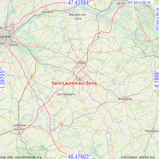
Saint-Laurent-sur-Sèvre GPS coordinates[2]
46° 57' 29.124" North, 0° 53' 38.112" West
| Map corner | latitude | longitude |
|---|---|---|
| Upper-left | 47.43584°, | -1.59705° |
| Center: | 46.95809°, | -0.89392° |
| Lower-right: | 46.47603°, | -0.1908° |
| Map W x H: | 106.7×106.7 km | = 66.3×66.3mi |
| max Lat: | 51.07786° ⇑55.7% North |
| Saint-Laurent-sur-Sèvre: | 46.95809° |
| min Lat: | ⇓44.3% South 41.3874° |
| min Long | Saint-Laurent-s | max Long |
| -5.08615° | -0.89392° | 9.52242° |
| W 12.7%⇐ | ⇒87.3% E |
Elevation
Elevation of Saint-Laurent-sur-Sèvre is 130 m = 427 ft, and this is 63.7 m = 209 ft below average elevation for this country.
| Max E: |
2333 m = 7654 ft | 50.5% |
| Avg. | 193.7 m = 635 ft | |
| Saint-Laurent-sur-Sèvre | 130 m = 427 ft | |
Min E: |
-1 m = -3 ft | 49.5% |
See also: France elevation on elevation.city.
Geographical zone
Saint-Laurent-sur-Sèvre is located in North temperate zone (between Tropic of Cancer and the Arctic Circle). Distance of this North polar circle is 2179.9 km =1354.5 mi to North.| Distance of | km | miles | from Saint-Laurent-sur-Sèvre |
|---|---|---|---|
| North Pole | 4785.8 | 2973.8 | to North |
| Arctic Circle | 2179.9 | 1354.5 | to North |
| Tropic Cancer | 2615.3 | 1625.1 | to South |
| Equator | 5221.3 | 3244.4 | to South |


Nearby cities:
15 places around Saint-Laurent-sur-Sèvre: (largest is in red/bold)
• Chambretaud
6.7 km =4.2 mi,  232°
232°
• Cholet
11.3 km =7 mi,  5°
5°
• La Séguinière
12.2 km =7.6 mi,  343°
343°
• La Tessoualle
6.1 km =3.8 mi,  31°
31°
• La Verrie
7.8 km =4.8 mi,  272°
272°
• Les Epesses
8.3 km =5.2 mi,  183°
183°
• Mazières-en-Mauges
11.3 km =7 mi, 31°
• Mortagne-sur-Sèvre
5.5 km =3.4 mi,  312°
312°
• Saint-Aubin-des-Ormeaux
11.9 km =7.4 mi,  288°
288°
• Saint-Christophe-du-Bois
8.9 km =5.5 mi,  334°
334°
• Saint-Malô-du-Bois
2.8 km =1.7 mi,  189°
189°
• Saint-Mars-la-Réorthe
10.9 km =6.8 mi, 192°
• Saint-Martin-des-Tilleuls
11.9 km =7.4 mi,  278°
278°
• Saint-Pierre-des-Échaubrognes
11.9 km =7.4 mi,  73°
73°
• Treize-Vents
5.3 km =3.3 mi,  140°
140°
Sources, notices
• [Note1] Compared only with cities in France existing in our database
• [Src1] Map data: © OpenStreetMap contributors (CC-BY-SA)
• [Src2] Other city data from geonames.org with taken over terms of usage.
• [Src3] Geographical zone / Annual Mean Temperature by Robert A. Rohde @ Wikipedia
