Saint-Christoly-de-Blaye geodata
Saint-Christoly-de-Blaye (Nouvelle-Aquitaine) is a populated place; located in France in Europe/Paris (GMT+2) time zone. With population of 1,955 people, there are 4896 cities with bigger population in this country. Compared to other cities in France, 78.2% of cities are located further ↑North; 83.5% of cities are located further →East and 85.9% of cities have higher elevation than Saint-Christoly-de-Blaye. Note1
Administrative division(s):
- Level 1: Nouvelle-Aquitaine
- Level 2: Gironde
- Level 3: Arrondissement de Blaye
- Level 4: Saint-Christoly-de-Blaye
Current local time in Saint-Christoly-de-Blaye:
02:20 PM, SaturdayDifference from your time zone: hours


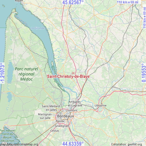
Saint-Christoly-de-Blaye GPS coordinates[2]
45° 7' 54.444" North, 0° 30' 27.36" West
| Map corner | latitude | longitude |
|---|---|---|
| Upper-left | 45.62567°, | -1.21073° |
| Center: | 45.13179°, | -0.5076° |
| Lower-right: | 44.63359°, | 0.19553° |
| Map W x H: | 110.3×110.3 km | = 68.5×68.5mi |
| max Lat: | 51.07786° ⇑78.2% North |
| Saint-Christoly-de-Blaye: | 45.13179° |
| min Lat: | ⇓21.8% South 41.3874° |
| min Long | Saint-Christoly | max Long |
| -5.08615° | -0.5076° | 9.52242° |
| W 16.5%⇐ | ⇒83.5% E |
Elevation
Elevation of Saint-Christoly-de-Blaye is 40 m = 131 ft, and this is 153.7 m = 504 ft below average elevation for this country.
| Max E: |
2333 m = 7654 ft | 85.9% |
| Avg. | 193.7 m = 635 ft | |
| Saint-Christoly-de-Blaye | 40 m = 131 ft | |
Min E: |
-1 m = -3 ft | 14.1% |
See also: France elevation on elevation.city.
Geographical zone
Saint-Christoly-de-Blaye is located in North temperate zone (between Tropic of Cancer and the Arctic Circle). Distance of this North polar circle is 2383 km =1480.7 mi to North.| Distance of | km | miles | from Saint-Christoly-de-Blaye |
|---|---|---|---|
| North Pole | 4988.9 | 3100 | to North |
| Arctic Circle | 2383 | 1480.7 | to North |
| Tropic Cancer | 2412.3 | 1498.9 | to South |
| Equator | 5018.2 | 3118.2 | to South |


Nearby cities:
15 places around Saint-Christoly-de-Blaye: (largest is in red/bold)
• Berson
6.9 km =4.3 mi,  246°
246°
• Cars
8.8 km =5.5 mi,  268°
268°
• Cartelègue
8.3 km =5.2 mi,  315°
315°
• Civrac-de-Blaye
5.5 km =3.4 mi,  113°
113°
• Cézac
8.3 km =5.2 mi,  123°
123°
• Générac
6.3 km =3.9 mi,  329°
329°
• Lansac
8.3 km =5.2 mi,  199°
199°
• Pugnac
5.6 km =3.5 mi,  170°
170°
• Saint-Girons-d’Aiguevives
2.9 km =1.8 mi,  287°
287°
• Saint-Mariens
8.6 km =5.3 mi,  101°
101°
• Saint-Paul
7.8 km =4.8 mi,  283°
283°
• Saint-Savin
5 km =3.1 mi,  65°
65°
• Saint-Yzan-de-Soudiac
7.7 km =4.8 mi,  82°
82°
• Tauriac
9.2 km =5.7 mi,  176°
176°
• Teuillac
5.4 km =3.4 mi,  215°
215°
Sources, notices
• [Note1] Compared only with cities in France existing in our database
• [Src1] Map data: © OpenStreetMap contributors (CC-BY-SA)
• [Src2] Other city data from geonames.org with taken over terms of usage.
• [Src3] Geographical zone / Annual Mean Temperature by Robert A. Rohde @ Wikipedia
