Cartelègue geodata
Cartelègue (Nouvelle-Aquitaine) is a populated place; located in France in Europe/Paris (GMT+2) time zone. With population of 965 people, there are 9092 cities with bigger population in this country. Compared to other cities in France, 77.6% of cities are located further ↑North; 84.3% of cities are located further →East and 92% of cities have higher elevation than Cartelègue. Note1
Administrative division(s):
- Level 1: Nouvelle-Aquitaine
- Level 2: Gironde
- Level 3: Arrondissement de Blaye
- Level 4: Cartelègue


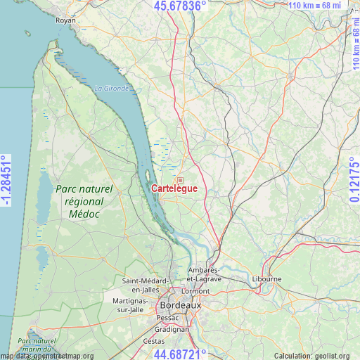
Cartelègue GPS coordinates[2]
45° 11' 5.784" North, 0° 34' 52.968" West
| Map corner | latitude | longitude |
|---|---|---|
| Upper-left | 45.67836°, | -1.28451° |
| Center: | 45.18494°, | -0.58138° |
| Lower-right: | 44.68721°, | 0.12175° |
| Map W x H: | 110.2×110.2 km | = 68.5×68.5mi |
| max Lat: | 51.07786° ⇑77.6% North |
| Cartelègue: | 45.18494° |
| min Lat: | ⇓22.4% South 41.3874° |
| min Long | Cartelègue | max Long |
| -5.08615° | -0.58138° | 9.52242° |
| W 15.7%⇐ | ⇒84.3% E |
Elevation
Elevation of Cartelègue is 25 m = 82 ft, and this is 168.7 m = 553 ft below average elevation for this country.
| Max E: |
2333 m = 7654 ft | 92% |
| Avg. | 193.7 m = 635 ft | |
| Cartelègue | 25 m = 82 ft | |
Min E: |
-1 m = -3 ft | 8% |
See also: France elevation on elevation.city.
Geographical zone
Cartelègue is located in North temperate zone (between Tropic of Cancer and the Arctic Circle). Distance of this North polar circle is 2377.1 km =1477.1 mi to North.| Distance of | km | miles | from Cartelègue |
|---|---|---|---|
| North Pole | 4983 | 3096.3 | to North |
| Arctic Circle | 2377.1 | 1477.1 | to North |
| Tropic Cancer | 2418.2 | 1502.6 | to South |
| Equator | 5024.1 | 3121.8 | to South |


Nearby cities:
15 places around Cartelègue: (largest is in red/bold)
• Anglade
5 km =3.1 mi,  302°
302°
• Berson
8.7 km =5.4 mi,  183°
183°
• Blaye
9 km =5.6 mi,  224°
224°
• Braud-et-Saint-Louis
7.7 km =4.8 mi,  333°
333°
• Cars
6.9 km =4.3 mi,  205°
205°
• Eyrans
2.8 km =1.7 mi,  276°
276°
• Générac
2.7 km =1.7 mi,  101°
101°
• Reignac
8 km =5 mi,  47°
47°
• Saint-Androny
5.3 km =3.3 mi,  274°
274°
• Saint-Christoly-de-Blaye
8.3 km =5.2 mi,  135°
135°
• Saint-Girons-d’Aiguevives
5.9 km =3.7 mi,  148°
148°
• Saint-Martin-Lacaussade
6.5 km =4 mi,  228°
228°
• Saint-Paul
4.5 km =2.8 mi,  203°
203°
• Saint-Seurin-de-Cursac
4.2 km =2.6 mi, 230°
• Étauliers
4.6 km =2.9 mi,  8°
8°
Sources, notices
• [Note1] Compared only with cities in France existing in our database
• [Src1] Map data: © OpenStreetMap contributors (CC-BY-SA)
• [Src2] Other city data from geonames.org with taken over terms of usage.
• [Src3] Geographical zone / Annual Mean Temperature by Robert A. Rohde @ Wikipedia
