Berson geodata
Berson (Nouvelle-Aquitaine) is a populated place; located in France in Europe/Paris (GMT+2) time zone. With population of 1,658 people, there are 5641 cities with bigger population in this country. Compared to other cities in France, 78.5% of cities are located further ↑North; 84.4% of cities are located further →East and 75.4% of cities have higher elevation than Berson. Note1
Administrative division(s):
- Level 1: Nouvelle-Aquitaine
- Level 2: Gironde
- Level 3: Arrondissement de Blaye
- Level 4: Berson


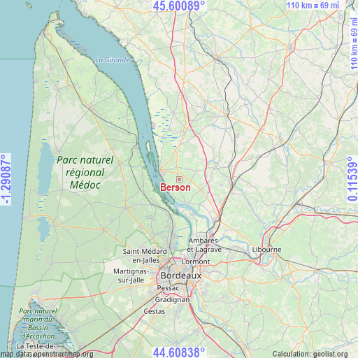
Berson GPS coordinates[2]
45° 6' 24.444" North, 0° 35' 15.864" West
| Map corner | latitude | longitude |
|---|---|---|
| Upper-left | 45.60089°, | -1.29087° |
| Center: | 45.10679°, | -0.58774° |
| Lower-right: | 44.60838°, | 0.11539° |
| Map W x H: | 110.4×110.4 km | = 68.6×68.6mi |
| max Lat: | 51.07786° ⇑78.5% North |
| Berson: | 45.10679° |
| min Lat: | ⇓21.5% South 41.3874° |
| min Long | Berson | max Long |
| -5.08615° | -0.58774° | 9.52242° |
| W 15.6%⇐ | ⇒84.4% E |
Elevation
Elevation of Berson is 66 m = 217 ft, and this is 127.7 m = 419 ft below average elevation for this country.
| Max E: |
2333 m = 7654 ft | 75.4% |
| Avg. | 193.7 m = 635 ft | |
| Berson | 66 m = 217 ft | |
Min E: |
-1 m = -3 ft | 24.6% |
See also: France elevation on elevation.city.
Geographical zone
Berson is located in North temperate zone (between Tropic of Cancer and the Arctic Circle). Distance of this North polar circle is 2385.8 km =1482.5 mi to North.| Distance of | km | miles | from Berson |
|---|---|---|---|
| North Pole | 4991.7 | 3101.7 | to North |
| Arctic Circle | 2385.8 | 1482.5 | to North |
| Tropic Cancer | 2409.5 | 1497.2 | to South |
| Equator | 5015.4 | 3116.4 | to South |


Nearby cities:
15 places around Berson: (largest is in red/bold)
• Bayon-sur-Gironde
6.3 km =3.9 mi,  176°
176°
• Blaye
6.3 km =3.9 mi,  291°
291°
• Bourg
7.7 km =4.8 mi,  162°
162°
• Cars
3.5 km =2.2 mi,  314°
314°
• Gauriac
5 km =3.1 mi,  203°
203°
• Lansac
6.1 km =3.8 mi,  144°
144°
• Plassac
4.6 km =2.9 mi,  265°
265°
• Pugnac
7.7 km =4.8 mi,  111°
111°
• Saint-Christoly-de-Blaye
6.9 km =4.3 mi,  66°
66°
• Saint-Ciers-de-Canesse
3.1 km =1.9 mi,  212°
212°
• Saint-Girons-d’Aiguevives
5.1 km =3.2 mi,  44°
44°
• Saint-Martin-Lacaussade
6.2 km =3.9 mi,  315°
315°
• Saint-Paul
4.8 km =3 mi,  344°
344°
• Saint-Seurin-de-Cursac
6.6 km =4.1 mi, 335°
• Teuillac
3.6 km =2.2 mi,  116°
116°
Sources, notices
• [Note1] Compared only with cities in France existing in our database
• [Src1] Map data: © OpenStreetMap contributors (CC-BY-SA)
• [Src2] Other city data from geonames.org with taken over terms of usage.
• [Src3] Geographical zone / Annual Mean Temperature by Robert A. Rohde @ Wikipedia
