Saint-Paul geodata
Saint-Paul (Nouvelle-Aquitaine) is a populated place; located in France in Europe/Paris (GMT+2) time zone. With population of 890 people, there are 9743 cities with bigger population in this country. Compared to other cities in France, 78% of cities are located further ↑North; 84.5% of cities are located further →East and 89.1% of cities have higher elevation than Saint-Paul. Note1
Administrative division(s):
- Level 1: Nouvelle-Aquitaine
- Level 2: Gironde
- Level 3: Arrondissement de Blaye
- Level 4: Saint-Paul


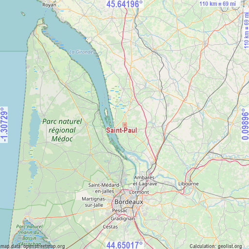
Saint-Paul GPS coordinates[2]
45° 8' 53.592" North, 0° 36' 14.976" West
| Map corner | latitude | longitude |
|---|---|---|
| Upper-left | 45.64196°, | -1.30729° |
| Center: | 45.14822°, | -0.60416° |
| Lower-right: | 44.65017°, | 0.09896° |
| Map W x H: | 110.3×110.3 km | = 68.5×68.5mi |
| max Lat: | 51.07786° ⇑78% North |
| Saint-Paul: | 45.14822° |
| min Lat: | ⇓22% South 41.3874° |
| min Long | Saint-Paul | max Long |
| -5.08615° | -0.60416° | 9.52242° |
| W 15.5%⇐ | ⇒84.5% E |
Elevation
Elevation of Saint-Paul is 32 m = 105 ft, and this is 161.7 m = 531 ft below average elevation for this country.
| Max E: |
2333 m = 7654 ft | 89.1% |
| Avg. | 193.7 m = 635 ft | |
| Saint-Paul | 32 m = 105 ft | |
Min E: |
-1 m = -3 ft | 10.9% |
See also: France elevation on elevation.city.
Geographical zone
Saint-Paul is located in North temperate zone (between Tropic of Cancer and the Arctic Circle). Distance of this North polar circle is 2381.2 km =1479.6 mi to North.| Distance of | km | miles | from Saint-Paul |
|---|---|---|---|
| North Pole | 4987.1 | 3098.8 | to North |
| Arctic Circle | 2381.2 | 1479.6 | to North |
| Tropic Cancer | 2414.1 | 1500.1 | to South |
| Equator | 5020 | 3119.3 | to South |


Nearby cities:
15 places around Saint-Paul: (largest is in red/bold)
• Anglade
7.2 km =4.5 mi,  340°
340°
• Berson
4.8 km =3 mi,  164°
164°
• Blaye
5.1 km =3.2 mi,  243°
243°
• Cars
2.4 km =1.5 mi,  209°
209°
• Cartelègue
4.5 km =2.8 mi,  23°
23°
• Eyrans
4.5 km =2.8 mi,  347°
347°
• Générac
5.7 km =3.5 mi,  50°
50°
• Plassac
5.9 km =3.7 mi, 213°
• Saint-Androny
5.8 km =3.6 mi,  322°
322°
• Saint-Christoly-de-Blaye
7.8 km =4.8 mi,  103°
103°
• Saint-Ciers-de-Canesse
7.2 km =4.5 mi,  183°
183°
• Saint-Girons-d’Aiguevives
4.9 km =3 mi, 101°
• Saint-Martin-Lacaussade
3.1 km =1.9 mi,  266°
266°
• Saint-Seurin-de-Cursac
2 km =1.2 mi,  313°
313°
• Teuillac
7.6 km =4.7 mi,  144°
144°
Sources, notices
• [Note1] Compared only with cities in France existing in our database
• [Src1] Map data: © OpenStreetMap contributors (CC-BY-SA)
• [Src2] Other city data from geonames.org with taken over terms of usage.
• [Src3] Geographical zone / Annual Mean Temperature by Robert A. Rohde @ Wikipedia
