Teuillac geodata
Teuillac (Nouvelle-Aquitaine) is a populated place; located in France in Europe/Paris (GMT+2) time zone. With population of 728 people, there are 11431 cities with bigger population in this country. Compared to other cities in France, 78.6% of cities are located further ↑North; 83.9% of cities are located further →East and 87.1% of cities have higher elevation than Teuillac. Note1
Administrative division(s):
- Level 1: Nouvelle-Aquitaine
- Level 2: Gironde
- Level 3: Arrondissement de Blaye
- Level 4: Teuillac


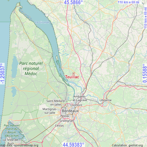
Teuillac GPS coordinates[2]
45° 5' 32.532" North, 0° 32' 50.1" West
| Map corner | latitude | longitude |
|---|---|---|
| Upper-left | 45.5866°, | -1.25037° |
| Center: | 45.09237°, | -0.54725° |
| Lower-right: | 44.59383°, | 0.15588° |
| Map W x H: | 110.4×110.4 km | = 68.6×68.6mi |
| max Lat: | 51.07786° ⇑78.6% North |
| Teuillac: | 45.09237° |
| min Lat: | ⇓21.4% South 41.3874° |
| min Long | Teuillac | max Long |
| -5.08615° | -0.54725° | 9.52242° |
| W 16.1%⇐ | ⇒83.9% E |
Elevation
Elevation of Teuillac is 37 m = 121 ft, and this is 156.7 m = 514 ft below average elevation for this country.
| Max E: |
2333 m = 7654 ft | 87.1% |
| Avg. | 193.7 m = 635 ft | |
| Teuillac | 37 m = 121 ft | |
Min E: |
-1 m = -3 ft | 12.9% |
See also: France elevation on elevation.city.
Geographical zone
Teuillac is located in North temperate zone (between Tropic of Cancer and the Arctic Circle). Distance of this North polar circle is 2387.4 km =1483.5 mi to North.| Distance of | km | miles | from Teuillac |
|---|---|---|---|
| North Pole | 4993.3 | 3102.7 | to North |
| Arctic Circle | 2387.4 | 1483.5 | to North |
| Tropic Cancer | 2407.9 | 1496.2 | to South |
| Equator | 5013.8 | 3115.4 | to South |


Nearby cities:
15 places around Teuillac: (largest is in red/bold)
• Bayon-sur-Gironde
5.5 km =3.4 mi,  211°
211°
• Berson
3.6 km =2.2 mi,  296°
296°
• Bourg
5.8 km =3.6 mi,  189°
189°
• Cars
7 km =4.3 mi,  305°
305°
• Civrac-de-Blaye
8.5 km =5.3 mi,  75°
75°
• Gauriac
6 km =3.7 mi,  240°
240°
• Lansac
3.4 km =2.1 mi,  173°
173°
• Marcamps
7.2 km =4.5 mi,  143°
143°
• Plassac
7.8 km =4.8 mi,  279°
279°
• Pugnac
4.2 km =2.6 mi,  106°
106°
• Saint-Christoly-de-Blaye
5.4 km =3.4 mi,  35°
35°
• Saint-Ciers-de-Canesse
4.9 km =3 mi,  258°
258°
• Saint-Girons-d’Aiguevives
5.2 km =3.2 mi,  4°
4°
• Saint-Paul
7.6 km =4.7 mi,  324°
324°
• Tauriac
6 km =3.7 mi, 142°
Sources, notices
• [Note1] Compared only with cities in France existing in our database
• [Src1] Map data: © OpenStreetMap contributors (CC-BY-SA)
• [Src2] Other city data from geonames.org with taken over terms of usage.
• [Src3] Geographical zone / Annual Mean Temperature by Robert A. Rohde @ Wikipedia
