Saint-Christol geodata
Saint-Christol (Occitanie) is a populated place; located in France in Europe/Paris (GMT+2) time zone. With population of 1,367 people, there are 6735 cities with bigger population in this country. Compared to other cities in France, 90% of cities are located further ↑North; 68.6% of cities are located further ←West and 73.6% of cities have higher elevation than Saint-Christol. Note1
Administrative division(s):
- Level 1: Occitanie
- Level 2: Département de l'Hérault
- Level 3: Arrondissement of Montpellier
- Level 4: Entre-Vignes


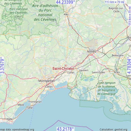
Saint-Christol GPS coordinates[2]
43° 43' 40.98" North, 4° 4' 47.676" East
| Map corner | latitude | longitude |
|---|---|---|
| Upper-left | 44.23399°, | 3.37679° |
| Center: | 43.72805°, | 4.07991° |
| Lower-right: | 43.2178°, | 4.78304° |
| Map W x H: | 113×113 km | = 70.2×70.2mi |
| max Lat: | 51.07786° ⇑90% North |
| Saint-Christol: | 43.72805° |
| min Lat: | ⇓10% South 41.3874° |
| min Long | Saint-Christol | max Long |
| -5.08615° | 4.07991° | 9.52242° |
| W 68.6%⇐ | ⇒31.4% E |
Elevation
Elevation of Saint-Christol is 70 m = 230 ft, and this is 123.7 m = 406 ft below average elevation for this country.
| Max E: |
2333 m = 7654 ft | 73.6% |
| Avg. | 193.7 m = 635 ft | |
| Saint-Christol | 70 m = 230 ft | |
Min E: |
-1 m = -3 ft | 26.4% |
See also: France elevation on elevation.city.
Geographical zone
Saint-Christol is located in North temperate zone (between Tropic of Cancer and the Arctic Circle). Distance of this Northern Tropic circle is 2256.2 km =1401.9 mi to South.| Distance of | km | miles | from Saint-Christol |
|---|---|---|---|
| North Pole | 5145 | 3197 | to North |
| Arctic Circle | 2539.1 | 1577.7 | to North |
| Tropic Cancer | 2256.2 | 1401.9 | to South |
| Equator | 4862.1 | 3021.2 | to South |


Nearby cities:
15 places around Saint-Christol: (largest is in red/bold)
• Aubais
6 km =3.7 mi,  61°
61°
• Beaulieu
4.7 km =2.9 mi,  270°
270°
• Boisseron
3.3 km =2.1 mi,  359°
359°
• Junas
5.8 km =3.6 mi,  34°
34°
• Lunel-Viel
5.6 km =3.5 mi,  169°
169°
• Restinclières
3.7 km =2.3 mi,  260°
260°
• Saint-Geniès-des-Mourgues
4.9 km =3 mi,  226°
226°
• Saint-Jean-de-Cornies
6.6 km =4.1 mi,  286°
286°
• Saint-Sériès
1.7 km =1.1 mi,  70°
70°
• Saturargues
2.7 km =1.7 mi,  103°
103°
• Saussines
4.2 km =2.6 mi,  332°
332°
• Sommières
6.4 km =4 mi,  7°
7°
• Sussargues
6.4 km =4 mi,  254°
254°
• Villetelle
4.6 km =2.9 mi,  85°
85°
• Vérargues
2.1 km =1.3 mi,  128°
128°
Sources, notices
• [Note1] Compared only with cities in France existing in our database
• [Src1] Map data: © OpenStreetMap contributors (CC-BY-SA)
• [Src2] Other city data from geonames.org with taken over terms of usage.
• [Src3] Geographical zone / Annual Mean Temperature by Robert A. Rohde @ Wikipedia
