Lunel-Viel geodata
Lunel-Viel (Occitanie) is a populated place; located in France in Europe/Paris (GMT+2) time zone. With population of 3,578 people, there are 2725 cities with bigger population in this country. Compared to other cities in France, 90.8% of cities are located further ↑North; 68.7% of cities are located further ←West and 95% of cities have higher elevation than Lunel-Viel. Note1
Administrative division(s):
- Level 1: Occitanie
- Level 2: Département de l'Hérault
- Level 3: Arrondissement of Montpellier
- Level 4: Lunel-Viel


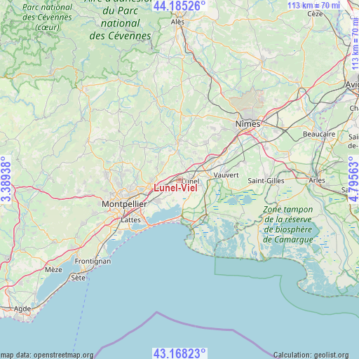
Lunel-Viel GPS coordinates[2]
43° 40' 44.04" North, 4° 5' 33" East
| Map corner | latitude | longitude |
|---|---|---|
| Upper-left | 44.18526°, | 3.38938° |
| Center: | 43.6789°, | 4.0925° |
| Lower-right: | 43.16823°, | 4.79563° |
| Map W x H: | 113.1×113.1 km | = 70.3×70.3mi |
| max Lat: | 51.07786° ⇑90.8% North |
| Lunel-Viel: | 43.6789° |
| min Lat: | ⇓9.2% South 41.3874° |
| min Long | Lunel-Viel | max Long |
| -5.08615° | 4.0925° | 9.52242° |
| W 68.7%⇐ | ⇒31.3% E |
Elevation
Elevation of Lunel-Viel is 17 m = 56 ft, and this is 176.7 m = 580 ft below average elevation for this country.
| Max E: |
2333 m = 7654 ft | 95% |
| Avg. | 193.7 m = 635 ft | |
| Lunel-Viel | 17 m = 56 ft | |
Min E: |
-1 m = -3 ft | 5% |
See also: France elevation on elevation.city.
Geographical zone
Lunel-Viel is located in North temperate zone (between Tropic of Cancer and the Arctic Circle). Distance of this Northern Tropic circle is 2250.7 km =1398.5 mi to South.| Distance of | km | miles | from Lunel-Viel |
|---|---|---|---|
| North Pole | 5150.4 | 3200.3 | to North |
| Arctic Circle | 2544.5 | 1581.1 | to North |
| Tropic Cancer | 2250.7 | 1398.5 | to South |
| Equator | 4856.6 | 3017.8 | to South |


Nearby cities:
15 places around Lunel-Viel: (largest is in red/bold)
• Baillargues
6.3 km =3.9 mi,  253°
253°
• Lansargues
3.4 km =2.1 mi,  204°
204°
• Lunel
3.5 km =2.2 mi,  92°
92°
• Marsillargues
6.8 km =4.2 mi,  103°
103°
• Restinclières
6.7 km =4.2 mi,  316°
316°
• Saint-Brès
5.1 km =3.2 mi,  255°
255°
• Saint-Christol
5.6 km =3.5 mi,  349°
349°
• Saint-Geniès-des-Mourgues
5 km =3.1 mi,  294°
294°
• Saint-Just
2.9 km =1.8 mi,  142°
142°
• Saint-Nazaire-de-Pézan
4.5 km =2.8 mi,  150°
150°
• Saint-Sériès
6.1 km =3.8 mi,  5°
5°
• Saturargues
5.1 km =3.2 mi,  18°
18°
• Valergues
2.8 km =1.7 mi,  244°
244°
• Villetelle
6.8 km =4.2 mi,  31°
31°
• Vérargues
4.2 km =2.6 mi, 8°
Sources, notices
• [Note1] Compared only with cities in France existing in our database
• [Src1] Map data: © OpenStreetMap contributors (CC-BY-SA)
• [Src2] Other city data from geonames.org with taken over terms of usage.
• [Src3] Geographical zone / Annual Mean Temperature by Robert A. Rohde @ Wikipedia
