Courson-Monteloup geodata
Courson-Monteloup (Île-de-France) is a populated place; located in France in Europe/Paris (GMT+2) time zone. With population of 621 people, there are 12967 cities with bigger population in this country. Compared to other cities in France, 70.9% of cities are located further ↓South; 55.1% of cities are located further →East and 63.6% of cities have higher elevation than Courson-Monteloup. Note1
Administrative division(s):
- Level 1: Île-de-France
- Level 2: Département de l'Essonne
- Level 3: Arrondissement de Palaiseau
- Level 4: Courson-Monteloup


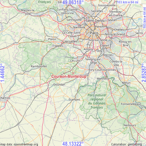
Courson-Monteloup GPS coordinates[2]
48° 36' 1.224" North, 2° 8' 59.1" East
| Map corner | latitude | longitude |
|---|---|---|
| Upper-left | 49.06318°, | 1.44662° |
| Center: | 48.60034°, | 2.14975° |
| Lower-right: | 48.13322°, | 2.85287° |
| Map W x H: | 103.4×103.4 km | = 64.2×64.2mi |
| max Lat: | 51.07786° ⇑29.1% North |
| Courson-Monteloup: | 48.60034° |
| min Lat: | ⇓70.9% South 41.3874° |
| min Long | Courson-Montelo | max Long |
| -5.08615° | 2.14975° | 9.52242° |
| W 44.9%⇐ | ⇒55.1% E |
Elevation
Elevation of Courson-Monteloup is 93 m = 305 ft, and this is 100.7 m = 330 ft below average elevation for this country.
| Max E: |
2333 m = 7654 ft | 63.6% |
| Avg. | 193.7 m = 635 ft | |
| Courson-Monteloup | 93 m = 305 ft | |
Min E: |
-1 m = -3 ft | 36.4% |
See also: France elevation on elevation.city.
Geographical zone
Courson-Monteloup is located in North temperate zone (between Tropic of Cancer and the Arctic Circle). Distance of this North polar circle is 1997.3 km =1241.1 mi to North.| Distance of | km | miles | from Courson-Monteloup |
|---|---|---|---|
| North Pole | 4603.2 | 2860.3 | to North |
| Arctic Circle | 1997.3 | 1241.1 | to North |
| Tropic Cancer | 2797.9 | 1738.5 | to South |
| Equator | 5403.9 | 3357.8 | to South |


Nearby cities:
15 places around Courson-Monteloup: (largest is in red/bold)
• Angervilliers
6.3 km =3.9 mi,  262°
262°
• Boissy-sous-Saint-Yon
6.9 km =4.3 mi,  138°
138°
• Bouville
6.9 km =4.3 mi,  236°
236°
• Breuillet
3.8 km =2.4 mi,  151°
151°
• Briis-sous-Forges
3.4 km =2.1 mi,  321°
321°
• Bruyères-le-Châtel
3.2 km =2 mi,  113°
113°
• Fontenay-lès-Briis
2.2 km =1.4 mi,  5°
5°
• Forges-les-Bains
4.7 km =2.9 mi,  313°
313°
• Janvry
5.3 km =3.3 mi,  2°
2°
• Ollainville
5.2 km =3.2 mi,  101°
101°
• Saint-Chéron
5.5 km =3.4 mi,  200°
200°
• Saint-Maurice-Montcouronne
2.7 km =1.7 mi,  223°
223°
• Saint-Yon
5.6 km =3.5 mi, 147°
• Vaugrigneuse
2 km =1.2 mi,  277°
277°
• Égly
6 km =3.7 mi, 114°
Sources, notices
• [Note1] Compared only with cities in France existing in our database
• [Src1] Map data: © OpenStreetMap contributors (CC-BY-SA)
• [Src2] Other city data from geonames.org with taken over terms of usage.
• [Src3] Geographical zone / Annual Mean Temperature by Robert A. Rohde @ Wikipedia
