Gausson geodata
Gausson (Brittany) is a populated place; located in France in Europe/Paris (GMT+2) time zone. With population of 607 people, there are 13209 cities with bigger population in this country. Compared to other cities in France, 64.5% of cities are located further ↓South; 96.7% of cities are located further →East and 65.2% of cities have lower elevation than Gausson. Note1
Administrative division(s):
- Level 1: Brittany
- Level 2: Département des Côtes-d’Armor
- Level 3: Arrondissement de Saint-Brieuc
- Level 4: Gausson


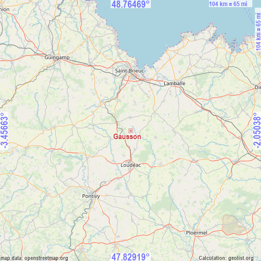
Gausson GPS coordinates[2]
48° 17' 56.688" North, 2° 45' 12.6" West
| Map corner | latitude | longitude |
|---|---|---|
| Upper-left | 48.76469°, | -3.45663° |
| Center: | 48.29908°, | -2.7535° |
| Lower-right: | 47.82919°, | -2.05038° |
| Map W x H: | 104×104 km | = 64.6×64.6mi |
| max Lat: | 51.07786° ⇑35.5% North |
| Gausson: | 48.29908° |
| min Lat: | ⇓64.5% South 41.3874° |
| min Long | Gausson | max Long |
| -5.08615° | -2.7535° | 9.52242° |
| W 3.3%⇐ | ⇒96.7% E |
Elevation
Elevation of Gausson is 195 m = 640 ft, and this is 1.3 m = 4 ft above average elevation for this country.
| Max E: |
2333 m = 7654 ft | 34.8% |
| Gausson | 195 m 640 ft | |
| Avg. | 193.7 m = 635 ft | |
Min E: |
-1 m = -3 ft | 65.2% |
See also: France elevation on elevation.city.
Geographical zone
Gausson is located in North temperate zone (between Tropic of Cancer and the Arctic Circle). Distance of this North polar circle is 2030.8 km =1261.9 mi to North.| Distance of | km | miles | from Gausson |
|---|---|---|---|
| North Pole | 4636.7 | 2881.1 | to North |
| Arctic Circle | 2030.8 | 1261.9 | to North |
| Tropic Cancer | 2764.4 | 1717.7 | to South |
| Equator | 5370.4 | 3337 | to South |


Nearby cities:
15 places around Gausson: (largest is in red/bold)
• Allineuc
8.9 km =5.5 mi,  278°
278°
• Hénon
10.8 km =6.7 mi,  28°
28°
• La Motte
7.4 km =4.6 mi,  168°
168°
• Langast
7 km =4.3 mi,  106°
106°
• Le Quillio
11.5 km =7.1 mi,  236°
236°
• Merléac
11 km =6.8 mi,  257°
257°
• Moncontour
11.2 km =7 mi,  52°
52°
• Plessala
10.3 km =6.4 mi,  104°
104°
• Plouguenast
4.1 km =2.5 mi,  117°
117°
• Plémy
6.7 km =4.2 mi, 51°
• Plœuc-sur-Lié
5.7 km =3.5 mi,  2°
2°
• Saint-Carreuc
11.2 km =7 mi,  8°
8°
• Trédaniel
11.9 km =7.4 mi,  56°
56°
• Trévé
10.2 km =6.3 mi,  196°
196°
• Uzel
6.7 km =4.2 mi,  251°
251°
Sources, notices
• [Note1] Compared only with cities in France existing in our database
• [Src1] Map data: © OpenStreetMap contributors (CC-BY-SA)
• [Src2] Other city data from geonames.org with taken over terms of usage.
• [Src3] Geographical zone / Annual Mean Temperature by Robert A. Rohde @ Wikipedia
