Cénac geodata
Cénac (Nouvelle-Aquitaine) is a populated place; located in France in Europe/Paris (GMT+2) time zone. With population of 1,854 people, there are 5117 cities with bigger population in this country. Compared to other cities in France, 81.5% of cities are located further ↑North; 82.9% of cities are located further →East and 75% of cities have higher elevation than Cénac. Note1
Administrative division(s):
- Level 1: Nouvelle-Aquitaine
- Level 2: Gironde
- Level 3: Arrondissement de Bordeaux
- Level 4: Cénac


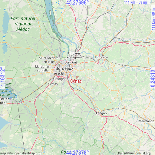
Cénac GPS coordinates[2]
44° 46' 48.108" North, 0° 27' 35.964" West
| Map corner | latitude | longitude |
|---|---|---|
| Upper-left | 45.27696°, | -1.16312° |
| Center: | 44.78003°, | -0.45999° |
| Lower-right: | 44.27878°, | 0.24313° |
| Map W x H: | 111×111 km | = 69×69mi |
| max Lat: | 51.07786° ⇑81.5% North |
| Cénac: | 44.78003° |
| min Lat: | ⇓18.5% South 41.3874° |
| min Long | Cénac | max Long |
| -5.08615° | -0.45999° | 9.52242° |
| W 17.1%⇐ | ⇒82.9% E |
Elevation
Elevation of Cénac is 67 m = 220 ft, and this is 126.7 m = 416 ft below average elevation for this country.
| Max E: |
2333 m = 7654 ft | 75% |
| Avg. | 193.7 m = 635 ft | |
| Cénac | 67 m = 220 ft | |
Min E: |
-1 m = -3 ft | 25% |
See also: France elevation on elevation.city.
Geographical zone
Cénac is located in North temperate zone (between Tropic of Cancer and the Arctic Circle). Distance of this Northern Tropic circle is 2373.2 km =1474.6 mi to South.| Distance of | km | miles | from Cénac |
|---|---|---|---|
| North Pole | 5028 | 3124.3 | to North |
| Arctic Circle | 2422.1 | 1505 | to North |
| Tropic Cancer | 2373.2 | 1474.6 | to South |
| Equator | 4979.1 | 3093.9 | to South |


Nearby cities:
15 places around Cénac: (largest is in red/bold)
• Baurech
6.3 km =3.9 mi,  164°
164°
• Bonnetan
5.3 km =3.3 mi,  41°
41°
• Bouliac
5.3 km =3.3 mi,  320°
320°
• Cadaujac
6.3 km =3.9 mi,  243°
243°
• Cambes
5.4 km =3.4 mi,  182°
182°
• Camblanes-et-Meynac
2.6 km =1.6 mi,  232°
232°
• Carignan-de-Bordeaux
2.9 km =1.8 mi, 320°
• Fargues-Saint-Hilaire
4.9 km =3 mi,  12°
12°
• Isle-Saint-Georges
6.2 km =3.9 mi,  189°
189°
• Latresne
2.5 km =1.6 mi,  285°
285°
• Lignan-de-Bordeaux
3.1 km =1.9 mi,  53°
53°
• Loupes
6.6 km =4.1 mi,  59°
59°
• Quinsac
3.5 km =2.2 mi,  217°
217°
• Sadirac
3.7 km =2.3 mi,  86°
86°
• Saint-Caprais-de-Bordeaux
4.2 km =2.6 mi,  148°
148°
Sources, notices
• [Note1] Compared only with cities in France existing in our database
• [Src1] Map data: © OpenStreetMap contributors (CC-BY-SA)
• [Src2] Other city data from geonames.org with taken over terms of usage.
• [Src3] Geographical zone / Annual Mean Temperature by Robert A. Rohde @ Wikipedia
