Quinsac geodata
Quinsac (Nouvelle-Aquitaine) is a populated place; located in France in Europe/Paris (GMT+2) time zone. With population of 1,907 people, there are 5017 cities with bigger population in this country. Compared to other cities in France, 81.7% of cities are located further ↑North; 83.2% of cities are located further →East and 80.6% of cities have higher elevation than Quinsac. Note1
Administrative division(s):
- Level 1: Nouvelle-Aquitaine
- Level 2: Gironde
- Level 3: Arrondissement de Bordeaux
- Level 4: Quinsac


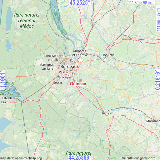
Quinsac GPS coordinates[2]
44° 45' 19.26" North, 0° 29' 13.092" West
| Map corner | latitude | longitude |
|---|---|---|
| Upper-left | 45.2525°, | -1.1901° |
| Center: | 44.75535°, | -0.48697° |
| Lower-right: | 44.25389°, | 0.21616° |
| Map W x H: | 111×111 km | = 69×69mi |
| max Lat: | 51.07786° ⇑81.7% North |
| Quinsac: | 44.75535° |
| min Lat: | ⇓18.3% South 41.3874° |
| min Long | Quinsac | max Long |
| -5.08615° | -0.48697° | 9.52242° |
| W 16.8%⇐ | ⇒83.2% E |
Elevation
Elevation of Quinsac is 53 m = 174 ft, and this is 140.7 m = 462 ft below average elevation for this country.
| Max E: |
2333 m = 7654 ft | 80.6% |
| Avg. | 193.7 m = 635 ft | |
| Quinsac | 53 m = 174 ft | |
Min E: |
-1 m = -3 ft | 19.4% |
See also: France elevation on elevation.city.
Geographical zone
Quinsac is located in North temperate zone (between Tropic of Cancer and the Arctic Circle). Distance of this Northern Tropic circle is 2370.4 km =1472.9 mi to South.| Distance of | km | miles | from Quinsac |
|---|---|---|---|
| North Pole | 5030.7 | 3125.9 | to North |
| Arctic Circle | 2424.8 | 1506.7 | to North |
| Tropic Cancer | 2370.4 | 1472.9 | to South |
| Equator | 4976.3 | 3092.1 | to South |


Nearby cities:
15 places around Quinsac: (largest is in red/bold)
• Ayguemorte-les-Graves
5.1 km =3.2 mi,  174°
174°
• Baurech
5 km =3.1 mi,  130°
130°
• Beautiran
6.3 km =3.9 mi,  154°
154°
• Cadaujac
3.5 km =2.2 mi,  268°
268°
• Cambes
3.3 km =2.1 mi,  143°
143°
• Camblanes-et-Meynac
1.1 km =0.7 mi,  1°
1°
• Carignan-de-Bordeaux
5 km =3.1 mi, 3°
• Cénac
3.5 km =2.2 mi,  37°
37°
• Isle-Saint-Georges
3.5 km =2.2 mi,  161°
161°
• Latresne
3.4 km =2.1 mi,  356°
356°
• Martillac
6.3 km =3.9 mi,  218°
218°
• Sadirac
6.5 km =4 mi,  63°
63°
• Saint-Caprais-de-Bordeaux
4.4 km =2.7 mi,  100°
100°
• Saint-Médard-d’Eyrans
4.9 km =3 mi,  208°
208°
• Villenave-d’Ornon
4.9 km =3 mi,  293°
293°
Sources, notices
• [Note1] Compared only with cities in France existing in our database
• [Src1] Map data: © OpenStreetMap contributors (CC-BY-SA)
• [Src2] Other city data from geonames.org with taken over terms of usage.
• [Src3] Geographical zone / Annual Mean Temperature by Robert A. Rohde @ Wikipedia
