Saint-Cannat geodata
Saint-Cannat (Provence-Alpes-Côte d'Azur) is a populated place; located in France in Europe/Paris (GMT+2) time zone. With population of 4,879 people, there are 2034 cities with bigger population in this country. Compared to other cities in France, 91.6% of cities are located further ↑North; 80.6% of cities are located further ←West and 70.1% of cities have lower elevation than Saint-Cannat. Note1
Administrative division(s):
- Level 1: Provence-Alpes-Côte d'Azur
- Level 2: Département des Bouches-du-Rhône
- Level 3: Aix-en-Provence
- Level 4: Saint-Cannat


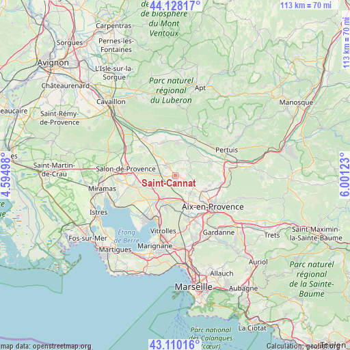
Saint-Cannat GPS coordinates[2]
43° 37' 16.752" North, 5° 17' 53.16" East
| Map corner | latitude | longitude |
|---|---|---|
| Upper-left | 44.12817°, | 4.59498° |
| Center: | 43.62132°, | 5.2981° |
| Lower-right: | 43.11016°, | 6.00123° |
| Map W x H: | 113.2×113.2 km | = 70.3×70.3mi |
| max Lat: | 51.07786° ⇑91.6% North |
| Saint-Cannat: | 43.62132° |
| min Lat: | ⇓8.4% South 41.3874° |
| min Long | Saint-Cannat | max Long |
| -5.08615° | 5.2981° | 9.52242° |
| W 80.6%⇐ | ⇒19.4% E |
Elevation
Elevation of Saint-Cannat is 220 m = 722 ft, and this is 26.3 m = 86 ft above average elevation for this country.
| Max E: |
2333 m = 7654 ft | 29.9% |
| Saint-Cannat | 220 m 722 ft | |
| Avg. | 193.7 m = 635 ft | |
Min E: |
-1 m = -3 ft | 70.1% |
See also: France elevation on elevation.city.
Geographical zone
Saint-Cannat is located in North temperate zone (between Tropic of Cancer and the Arctic Circle). Distance of this Northern Tropic circle is 2244.3 km =1394.5 mi to South.| Distance of | km | miles | from Saint-Cannat |
|---|---|---|---|
| North Pole | 5156.8 | 3204.3 | to North |
| Arctic Circle | 2550.9 | 1585.1 | to North |
| Tropic Cancer | 2244.3 | 1394.5 | to South |
| Equator | 4850.2 | 3013.8 | to South |


Nearby cities:
15 places around Saint-Cannat: (largest is in red/bold)
• Aurons
12.3 km =7.6 mi,  293°
293°
• Charleval
11.6 km =7.2 mi,  338°
338°
• Coudoux
8.1 km =5 mi,  209°
209°
• La Barben
9.8 km =6.1 mi,  275°
275°
• La Fare-les-Oliviers
11.4 km =7.1 mi,  226°
226°
• La Roque-d’Anthéron
10.5 km =6.5 mi,  5°
5°
• Lambesc
4.6 km =2.9 mi,  321°
321°
• Lauris
14 km =8.7 mi, 5°
• Le Puy-Sainte-Réparade
12 km =7.5 mi,  66°
66°
• Pélissanne
11.8 km =7.3 mi, 276°
• Rognes
6.2 km =3.9 mi,  39°
39°
• Velaux
10.9 km =6.8 mi,  197°
197°
• Ventabren
9.2 km =5.7 mi,  181°
181°
• Vernègues
12.4 km =7.7 mi,  305°
305°
• Éguilles
7.5 km =4.7 mi,  141°
141°
Sources, notices
• [Note1] Compared only with cities in France existing in our database
• [Src1] Map data: © OpenStreetMap contributors (CC-BY-SA)
• [Src2] Other city data from geonames.org with taken over terms of usage.
• [Src3] Geographical zone / Annual Mean Temperature by Robert A. Rohde @ Wikipedia
