Aurons geodata
Aurons (Provence-Alpes-Côte d'Azur) is a populated place; located in France in Europe/Paris (GMT+2) time zone. With population of 541 people, there are 14367 cities with bigger population in this country. Compared to other cities in France, 91% of cities are located further ↑North; 79.3% of cities are located further ←West and 73.3% of cities have lower elevation than Aurons. Note1
Administrative division(s):
- Level 1: Provence-Alpes-Côte d'Azur
- Level 2: Département des Bouches-du-Rhône
- Level 3: Aix-en-Provence
- Level 4: Aurons


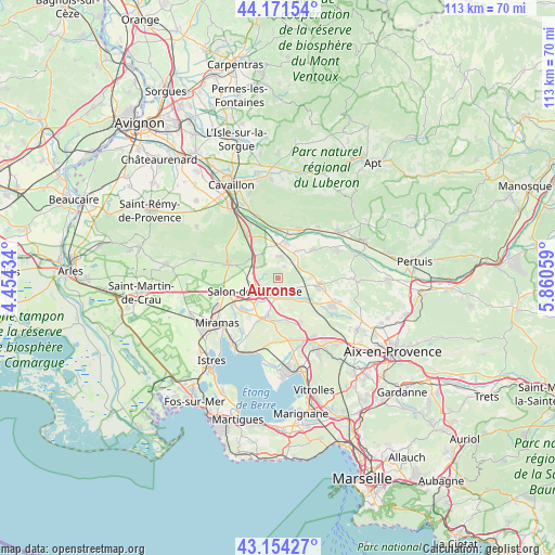
Aurons GPS coordinates[2]
43° 39' 54.216" North, 5° 9' 26.892" East
| Map corner | latitude | longitude |
|---|---|---|
| Upper-left | 44.17154°, | 4.45434° |
| Center: | 43.66506°, | 5.15747° |
| Lower-right: | 43.15427°, | 5.86059° |
| Map W x H: | 113.1×113.1 km | = 70.3×70.3mi |
| max Lat: | 51.07786° ⇑91% North |
| Aurons: | 43.66506° |
| min Lat: | ⇓9% South 41.3874° |
| min Long | Aurons | max Long |
| -5.08615° | 5.15747° | 9.52242° |
| W 79.3%⇐ | ⇒20.7% E |
Elevation
Elevation of Aurons is 238 m = 781 ft, and this is 44.3 m = 145 ft above average elevation for this country.
| Max E: |
2333 m = 7654 ft | 26.7% |
| Aurons | 238 m 781 ft | |
| Avg. | 193.7 m = 635 ft | |
Min E: |
-1 m = -3 ft | 73.3% |
See also: France elevation on elevation.city.
Geographical zone
Aurons is located in North temperate zone (between Tropic of Cancer and the Arctic Circle). Distance of this Northern Tropic circle is 2249.2 km =1397.6 mi to South.| Distance of | km | miles | from Aurons |
|---|---|---|---|
| North Pole | 5152 | 3201.3 | to North |
| Arctic Circle | 2546.1 | 1582.1 | to North |
| Tropic Cancer | 2249.2 | 1397.6 | to South |
| Equator | 4855.1 | 3016.8 | to South |


Nearby cities:
15 places around Aurons: (largest is in red/bold)
• Alleins
4.3 km =2.7 mi,  4°
4°
• Charleval
9.2 km =5.7 mi,  49°
49°
• Eyguières
10.7 km =6.6 mi,  288°
288°
• Grans
9.9 km =6.2 mi,  230°
230°
• La Barben
4.2 km =2.6 mi,  158°
158°
• Lamanon
6.7 km =4.2 mi,  304°
304°
• Lambesc
8.5 km =5.3 mi,  98°
98°
• Lançon-Provence
8.4 km =5.2 mi,  196°
196°
• Mallemort
7.6 km =4.7 mi,  13°
13°
• Mérindol
10.7 km =6.6 mi,  20°
20°
• Pélissanne
3.6 km =2.2 mi,  186°
186°
• Saint-Cannat
12.3 km =7.6 mi,  113°
113°
• Salon-de-Provence
5.6 km =3.5 mi,  243°
243°
• Sénas
10.8 km =6.7 mi,  323°
323°
• Vernègues
2.6 km =1.6 mi,  26°
26°
Sources, notices
• [Note1] Compared only with cities in France existing in our database
• [Src1] Map data: © OpenStreetMap contributors (CC-BY-SA)
• [Src2] Other city data from geonames.org with taken over terms of usage.
• [Src3] Geographical zone / Annual Mean Temperature by Robert A. Rohde @ Wikipedia
