Éguilles geodata
Éguilles (Provence-Alpes-Côte d'Azur) is a populated place; located in France in Europe/Paris (GMT+2) time zone. With population of 7,480 people, there are 1302 cities with bigger population in this country. Compared to other cities in France, 92.2% of cities are located further ↑North; 81.1% of cities are located further ←West and 77.9% of cities have lower elevation than Éguilles. Note1
Administrative division(s):
- Level 1: Provence-Alpes-Côte d'Azur
- Level 2: Département des Bouches-du-Rhône
- Level 3: Aix-en-Provence
- Level 4: Éguilles


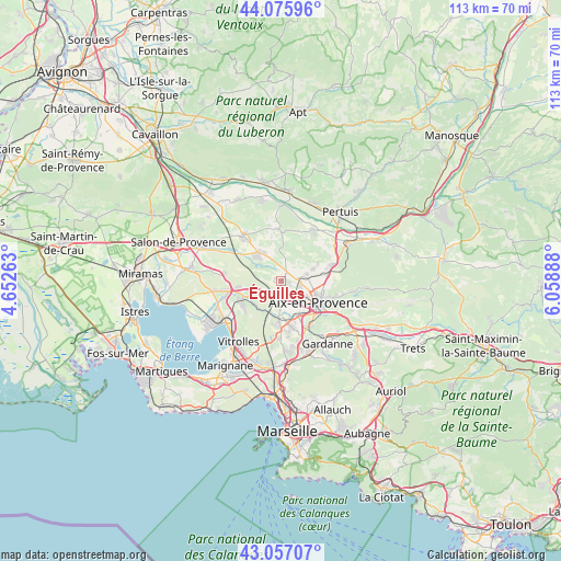
Éguilles GPS coordinates[2]
43° 34' 7.212" North, 5° 21' 20.7" East
| Map corner | latitude | longitude |
|---|---|---|
| Upper-left | 44.07596°, | 4.65263° |
| Center: | 43.56867°, | 5.35575° |
| Lower-right: | 43.05707°, | 6.05888° |
| Map W x H: | 113.3×113.3 km | = 70.4×70.4mi |
| max Lat: | 51.07786° ⇑92.2% North |
| Éguilles: | 43.56867° |
| min Lat: | ⇓7.8% South 41.3874° |
| min Long | Éguilles | max Long |
| -5.08615° | 5.35575° | 9.52242° |
| W 81.1%⇐ | ⇒18.9% E |
Elevation
Elevation of Éguilles is 271 m = 889 ft, and this is 77.3 m = 254 ft above average elevation for this country.
| Max E: |
2333 m = 7654 ft | 22.1% |
| Éguilles | 271 m 889 ft | |
| Avg. | 193.7 m = 635 ft | |
Min E: |
-1 m = -3 ft | 77.9% |
See also: France elevation on elevation.city.
Geographical zone
Éguilles is located in North temperate zone (between Tropic of Cancer and the Arctic Circle). Distance of this Northern Tropic circle is 2238.5 km =1390.9 mi to South.| Distance of | km | miles | from Éguilles |
|---|---|---|---|
| North Pole | 5162.7 | 3208 | to North |
| Arctic Circle | 2556.8 | 1588.7 | to North |
| Tropic Cancer | 2238.5 | 1390.9 | to South |
| Equator | 4844.4 | 3010.2 | to South |


Nearby cities:
15 places around Éguilles: (largest is in red/bold)
• Aix-en-Provence
8.8 km =5.5 mi,  120°
120°
• Bouc-Bel-Air
13.8 km =8.6 mi,  160°
160°
• Cabriès
14.3 km =8.9 mi,  172°
172°
• Coudoux
8.7 km =5.4 mi,  262°
262°
• La Fare-les-Oliviers
13.2 km =8.2 mi, 261°
• Lambesc
12.1 km =7.5 mi,  321°
321°
• Le Puy-Sainte-Réparade
12.4 km =7.7 mi,  31°
31°
• Le Tholonet
13.6 km =8.5 mi,  112°
112°
• Rognac
13.3 km =8.3 mi,  227°
227°
• Rognes
10.6 km =6.6 mi,  356°
356°
• Saint-Cannat
7.5 km =4.7 mi, 321°
• Saint-Marc-Jaumegarde
13.7 km =8.5 mi,  100°
100°
• Velaux
9.2 km =5.7 mi,  240°
240°
• Venelles
10.5 km =6.5 mi,  71°
71°
• Ventabren
5.9 km =3.7 mi, 235°
Sources, notices
• [Note1] Compared only with cities in France existing in our database
• [Src1] Map data: © OpenStreetMap contributors (CC-BY-SA)
• [Src2] Other city data from geonames.org with taken over terms of usage.
• [Src3] Geographical zone / Annual Mean Temperature by Robert A. Rohde @ Wikipedia
