Velaux geodata
Velaux (Provence-Alpes-Côte d'Azur) is a populated place; located in France in Europe/Paris (GMT+2) time zone. With population of 7,963 people, there are 1215 cities with bigger population in this country. Compared to other cities in France, 92.7% of cities are located further ↑North; 80.2% of cities are located further ←West and 68.7% of cities have higher elevation than Velaux. Note1
Administrative division(s):
- Level 1: Provence-Alpes-Côte d'Azur
- Level 2: Département des Bouches-du-Rhône
- Level 3: Aix-en-Provence
- Level 4: Velaux


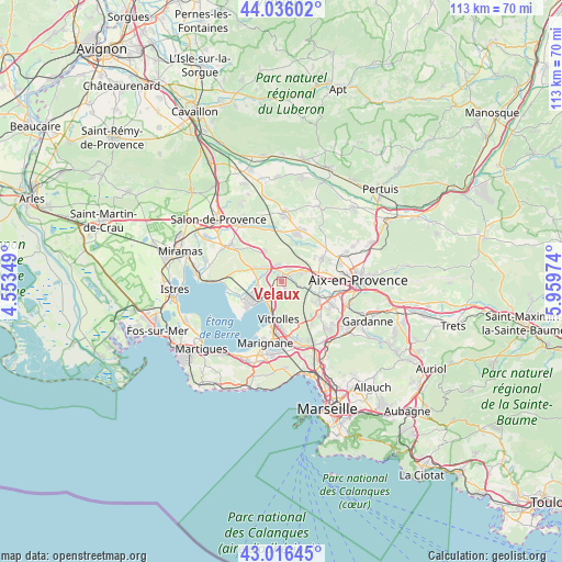
Velaux GPS coordinates[2]
43° 31' 42.204" North, 5° 15' 23.796" East
| Map corner | latitude | longitude |
|---|---|---|
| Upper-left | 44.03602°, | 4.55349° |
| Center: | 43.52839°, | 5.25661° |
| Lower-right: | 43.01645°, | 5.95974° |
| Map W x H: | 113.4×113.4 km | = 70.5×70.5mi |
| max Lat: | 51.07786° ⇑92.7% North |
| Velaux: | 43.52839° |
| min Lat: | ⇓7.3% South 41.3874° |
| min Long | Velaux | max Long |
| -5.08615° | 5.25661° | 9.52242° |
| W 80.2%⇐ | ⇒19.8% E |
Elevation
Elevation of Velaux is 81 m = 266 ft, and this is 112.7 m = 370 ft below average elevation for this country.
| Max E: |
2333 m = 7654 ft | 68.7% |
| Avg. | 193.7 m = 635 ft | |
| Velaux | 81 m = 266 ft | |
Min E: |
-1 m = -3 ft | 31.3% |
See also: France elevation on elevation.city.
Geographical zone
Velaux is located in North temperate zone (between Tropic of Cancer and the Arctic Circle). Distance of this Northern Tropic circle is 2234 km =1388.1 mi to South.| Distance of | km | miles | from Velaux |
|---|---|---|---|
| North Pole | 5167.2 | 3210.7 | to North |
| Arctic Circle | 2561.3 | 1591.5 | to North |
| Tropic Cancer | 2234 | 1388.1 | to South |
| Equator | 4839.9 | 3007.4 | to South |


Nearby cities:
15 places around Velaux: (largest is in red/bold)
• Berre-l'Étang
8.9 km =5.5 mi,  231°
231°
• Cabriès
13.8 km =8.6 mi,  134°
134°
• Coudoux
3.4 km =2.1 mi,  349°
349°
• La Barben
13 km =8.1 mi,  330°
330°
• La Fare-les-Oliviers
5.6 km =3.5 mi,  296°
296°
• Lambesc
14 km =8.7 mi,  1°
1°
• Lançon-Provence
12.6 km =7.8 mi, 304°
• Les Pennes-Mirabeau
13.8 km =8.6 mi,  162°
162°
• Marignane
12.8 km =8 mi,  195°
195°
• Rognac
4.9 km =3 mi, 202°
• Saint-Cannat
10.9 km =6.8 mi,  17°
17°
• Saint-Victoret
12.2 km =7.6 mi,  188°
188°
• Ventabren
3.3 km =2.1 mi,  70°
70°
• Vitrolles
7.6 km =4.7 mi,  184°
184°
• Éguilles
9.2 km =5.7 mi,  60°
60°
Sources, notices
• [Note1] Compared only with cities in France existing in our database
• [Src1] Map data: © OpenStreetMap contributors (CC-BY-SA)
• [Src2] Other city data from geonames.org with taken over terms of usage.
• [Src3] Geographical zone / Annual Mean Temperature by Robert A. Rohde @ Wikipedia
