Saint-Benoît-la-Forêt geodata
Saint-Benoît-la-Forêt (Centre) is a populated place; located in France in Europe/Paris (GMT+2) time zone. With population of 809 people, there are 10494 cities with bigger population in this country. Compared to other cities in France, 52.7% of cities are located further ↑North; 75.1% of cities are located further →East and 61.5% of cities have higher elevation than Saint-Benoît-la-Forêt. Note1
Administrative division(s):
- Level 1: Centre
- Level 2: Département d'Indre-et-Loire
- Level 3: Arrondissement de Chinon
- Level 4: Saint-Benoît-la-Forêt
Current local time in Saint-Benoît-la-Forêt:
02:22 PM, SaturdayDifference from your time zone: hours


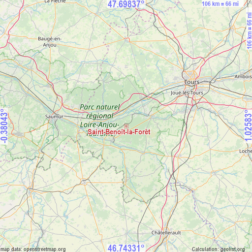
Saint-Benoît-la-Forêt GPS coordinates[2]
47° 13' 22.764" North, 0° 19' 21.72" East
| Map corner | latitude | longitude |
|---|---|---|
| Upper-left | 47.69837°, | -0.38043° |
| Center: | 47.22299°, | 0.3227° |
| Lower-right: | 46.74331°, | 1.02583° |
| Map W x H: | 106.2×106.2 km | = 66×66mi |
| max Lat: | 51.07786° ⇑52.7% North |
| Saint-Benoît-la-Forêt: | 47.22299° |
| min Lat: | ⇓47.3% South 41.3874° |
| min Long | Saint-Benoît-l | max Long |
| -5.08615° | 0.3227° | 9.52242° |
| W 24.9%⇐ | ⇒75.1% E |
Elevation
Elevation of Saint-Benoît-la-Forêt is 98 m = 322 ft, and this is 95.7 m = 314 ft below average elevation for this country.
| Max E: |
2333 m = 7654 ft | 61.5% |
| Avg. | 193.7 m = 635 ft | |
| Saint-Benoît-la-Forêt | 98 m = 322 ft | |
Min E: |
-1 m = -3 ft | 38.5% |
See also: France elevation on elevation.city.
Geographical zone
Saint-Benoît-la-Forêt is located in North temperate zone (between Tropic of Cancer and the Arctic Circle). Distance of this North polar circle is 2150.5 km =1336.3 mi to North.| Distance of | km | miles | from Saint-Benoît-la-Forêt |
|---|---|---|---|
| North Pole | 4756.4 | 2955.5 | to North |
| Arctic Circle | 2150.5 | 1336.3 | to North |
| Tropic Cancer | 2644.8 | 1643.4 | to South |
| Equator | 5250.7 | 3262.6 | to South |


Nearby cities:
15 places around Saint-Benoît-la-Forêt: (largest is in red/bold)
• Avoine
10.8 km =6.7 mi,  259°
259°
• Bréhémont
8.5 km =5.3 mi,  18°
18°
• Cheillé
7.6 km =4.7 mi,  55°
55°
• Chinon
8.7 km =5.4 mi,  224°
224°
• Cravant-les-Coteaux
7.4 km =4.6 mi,  166°
166°
• Huismes
5.5 km =3.4 mi,  281°
281°
• Ingrandes-de-Touraine
7.9 km =4.9 mi,  327°
327°
• La Chapelle-sur-Loire
8.4 km =5.2 mi,  291°
291°
• Panzoult
10.4 km =6.5 mi,  145°
145°
• Restigné
9.7 km =6 mi,  312°
312°
• Rigny-Ussé
3.7 km =2.3 mi, 331°
• Rivarennes
5.4 km =3.4 mi,  25°
25°
• Rivière
9.2 km =5.7 mi,  201°
201°
• Saint-Michel-sur-Loire
9.6 km =6 mi,  11°
11°
• Saint-Patrice
7.2 km =4.5 mi,  342°
342°
Sources, notices
• [Note1] Compared only with cities in France existing in our database
• [Src1] Map data: © OpenStreetMap contributors (CC-BY-SA)
• [Src2] Other city data from geonames.org with taken over terms of usage.
• [Src3] Geographical zone / Annual Mean Temperature by Robert A. Rohde @ Wikipedia
