Bréhémont geodata
Bréhémont (Centre) is a populated place; located in France in Europe/Paris (GMT+2) time zone. With population of 821 people, there are 10382 cities with bigger population in this country. Compared to other cities in France, 51.6% of cities are located further ↑North; 74.7% of cities are located further →East and 87.1% of cities have higher elevation than Bréhémont. Note1
Administrative division(s):
- Level 1: Centre
- Level 2: Département d'Indre-et-Loire
- Level 3: Arrondissement de Tours
- Level 4: Bréhémont


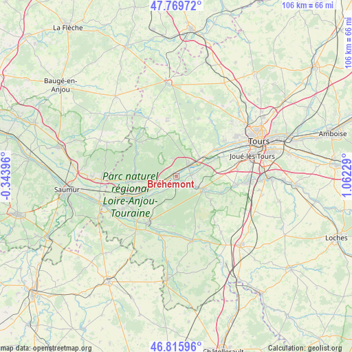
Bréhémont GPS coordinates[2]
47° 17' 41.964" North, 0° 21' 32.976" East
| Map corner | latitude | longitude |
|---|---|---|
| Upper-left | 47.76972°, | -0.34396° |
| Center: | 47.29499°, | 0.35916° |
| Lower-right: | 46.81596°, | 1.06229° |
| Map W x H: | 106×106 km | = 65.9×65.9mi |
| max Lat: | 51.07786° ⇑51.6% North |
| Bréhémont: | 47.29499° |
| min Lat: | ⇓48.4% South 41.3874° |
| min Long | Bréhémont | max Long |
| -5.08615° | 0.35916° | 9.52242° |
| W 25.3%⇐ | ⇒74.7% E |
Elevation
Elevation of Bréhémont is 37 m = 121 ft, and this is 156.7 m = 514 ft below average elevation for this country.
| Max E: |
2333 m = 7654 ft | 87.1% |
| Avg. | 193.7 m = 635 ft | |
| Bréhémont | 37 m = 121 ft | |
Min E: |
-1 m = -3 ft | 12.9% |
See also: France elevation on elevation.city.
Geographical zone
Bréhémont is located in North temperate zone (between Tropic of Cancer and the Arctic Circle). Distance of this North polar circle is 2142.5 km =1331.3 mi to North.| Distance of | km | miles | from Bréhémont |
|---|---|---|---|
| North Pole | 4748.4 | 2950.5 | to North |
| Arctic Circle | 2142.5 | 1331.3 | to North |
| Tropic Cancer | 2652.8 | 1648.4 | to South |
| Equator | 5258.7 | 3267.6 | to South |


Nearby cities:
15 places around Bréhémont: (largest is in red/bold)
• Azay-le-Rideau
9.1 km =5.7 mi,  112°
112°
• Cheillé
5.1 km =3.2 mi,  137°
137°
• Cinq-Mars-la-Pile
9.4 km =5.8 mi,  52°
52°
• Huismes
10.7 km =6.6 mi,  229°
229°
• Ingrandes-de-Touraine
7.1 km =4.4 mi,  259°
259°
• La Chapelle-aux-Naux
5.7 km =3.5 mi,  63°
63°
• Langeais
4.7 km =2.9 mi,  42°
42°
• Lignières-de-Touraine
4.4 km =2.7 mi,  86°
86°
• Restigné
10 km =6.2 mi, 261°
• Rigny-Ussé
6.5 km =4 mi,  223°
223°
• Rivarennes
3.2 km =2 mi,  188°
188°
• Saint-Benoît-la-Forêt
8.5 km =5.3 mi,  198°
198°
• Saint-Michel-sur-Loire
1.6 km =1 mi,  330°
330°
• Saint-Patrice
5 km =3.1 mi, 256°
• Vallères
8.9 km =5.5 mi,  78°
78°
Sources, notices
• [Note1] Compared only with cities in France existing in our database
• [Src1] Map data: © OpenStreetMap contributors (CC-BY-SA)
• [Src2] Other city data from geonames.org with taken over terms of usage.
• [Src3] Geographical zone / Annual Mean Temperature by Robert A. Rohde @ Wikipedia
