Chinon geodata
Chinon (Centre) is a seat of a third-order administrative division; located in France in Europe/Paris (GMT+2) time zone. With population of 9,405 people, there are 1022 cities with bigger population in this country. Compared to other cities in France, 53.4% of cities are located further ↑North; 75.8% of cities are located further →East and 66.6% of cities have higher elevation than Chinon. Note1
Administrative division(s):
- Level 1: Centre
- Level 2: Département d'Indre-et-Loire
- Level 3: Arrondissement de Chinon
- Level 4: Chinon


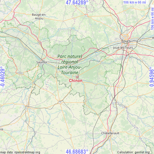
Chinon GPS coordinates[2]
47° 10' 1.236" North, 0° 14' 34.224" East
| Map corner | latitude | longitude |
|---|---|---|
| Upper-left | 47.64289°, | -0.46029° |
| Center: | 47.16701°, | 0.24284° |
| Lower-right: | 46.68683°, | 0.94596° |
| Map W x H: | 106.3×106.3 km | = 66.1×66.1mi |
| max Lat: | 51.07786° ⇑53.4% North |
| Chinon: | 47.16701° |
| min Lat: | ⇓46.6% South 41.3874° |
| min Long | Chinon | max Long |
| -5.08615° | 0.24284° | 9.52242° |
| W 24.2%⇐ | ⇒75.8% E |
Elevation
Elevation of Chinon is 86 m = 282 ft, and this is 107.7 m = 353 ft below average elevation for this country.
| Max E: |
2333 m = 7654 ft | 66.6% |
| Avg. | 193.7 m = 635 ft | |
| Chinon | 86 m = 282 ft | |
Min E: |
-1 m = -3 ft | 33.4% |
See also: France elevation on elevation.city.
Geographical zone
Chinon is located in North temperate zone (between Tropic of Cancer and the Arctic Circle). Distance of this North polar circle is 2156.7 km =1340.1 mi to North.| Distance of | km | miles | from Chinon |
|---|---|---|---|
| North Pole | 4762.6 | 2959.3 | to North |
| Arctic Circle | 2156.7 | 1340.1 | to North |
| Tropic Cancer | 2638.6 | 1639.5 | to South |
| Equator | 5244.5 | 3258.8 | to South |


Nearby cities:
15 places around Chinon: (largest is in red/bold)
• Avoine
6.2 km =3.9 mi,  313°
313°
• Beaumont-en-Véron
5.3 km =3.3 mi,  304°
304°
• Beuxes
9.4 km =5.8 mi,  210°
210°
• Chouzé-sur-Loire
11.9 km =7.4 mi, 310°
• Cravant-les-Coteaux
7.9 km =4.9 mi,  97°
97°
• Huismes
7.4 km =4.6 mi,  4°
4°
• La Chapelle-sur-Loire
9.5 km =5.9 mi,  348°
348°
• La Roche-Clermault
4.3 km =2.7 mi,  220°
220°
• Ligré
6.6 km =4.1 mi,  157°
157°
• Panzoult
12.2 km =7.6 mi, 101°
• Restigné
12.9 km =8 mi, 354°
• Rigny-Ussé
10.4 km =6.5 mi,  24°
24°
• Rivière
3.6 km =2.2 mi,  131°
131°
• Saint-Benoît-la-Forêt
8.7 km =5.4 mi,  44°
44°
• Savigny-en-Véron
8.3 km =5.2 mi, 296°
Sources, notices
• [Note1] Compared only with cities in France existing in our database
• [Src1] Map data: © OpenStreetMap contributors (CC-BY-SA)
• [Src2] Other city data from geonames.org with taken over terms of usage.
• [Src3] Geographical zone / Annual Mean Temperature by Robert A. Rohde @ Wikipedia
