Huismes geodata
Huismes (Centre) is a populated place; located in France in Europe/Paris (GMT+2) time zone. With population of 1,456 people, there are 6345 cities with bigger population in this country. Compared to other cities in France, 52.5% of cities are located further ↑North; 75.8% of cities are located further →East and 69.2% of cities have higher elevation than Huismes. Note1
Administrative division(s):
- Level 1: Centre
- Level 2: Département d'Indre-et-Loire
- Level 3: Arrondissement de Chinon
- Level 4: Huismes


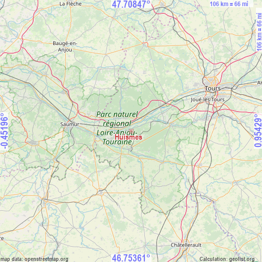
Huismes GPS coordinates[2]
47° 13' 59.484" North, 0° 15' 4.176" East
| Map corner | latitude | longitude |
|---|---|---|
| Upper-left | 47.70847°, | -0.45196° |
| Center: | 47.23319°, | 0.25116° |
| Lower-right: | 46.75361°, | 0.95429° |
| Map W x H: | 106.2×106.2 km | = 66×66mi |
| max Lat: | 51.07786° ⇑52.5% North |
| Huismes: | 47.23319° |
| min Lat: | ⇓47.5% South 41.3874° |
| min Long | Huismes | max Long |
| -5.08615° | 0.25116° | 9.52242° |
| W 24.2%⇐ | ⇒75.8% E |
Elevation
Elevation of Huismes is 80 m = 262 ft, and this is 113.7 m = 373 ft below average elevation for this country.
| Max E: |
2333 m = 7654 ft | 69.2% |
| Avg. | 193.7 m = 635 ft | |
| Huismes | 80 m = 262 ft | |
Min E: |
-1 m = -3 ft | 30.8% |
See also: France elevation on elevation.city.
Geographical zone
Huismes is located in North temperate zone (between Tropic of Cancer and the Arctic Circle). Distance of this North polar circle is 2149.3 km =1335.5 mi to North.| Distance of | km | miles | from Huismes |
|---|---|---|---|
| North Pole | 4755.2 | 2954.7 | to North |
| Arctic Circle | 2149.3 | 1335.5 | to North |
| Tropic Cancer | 2645.9 | 1644.1 | to South |
| Equator | 5251.8 | 3263.3 | to South |


Nearby cities:
15 places around Huismes: (largest is in red/bold)
• Avoine
6 km =3.7 mi,  239°
239°
• Beaumont-en-Véron
6.7 km =4.2 mi,  229°
229°
• Benais
7.4 km =4.6 mi,  339°
339°
• Bourgueil
8.5 km =5.3 mi,  310°
310°
• Chinon
7.4 km =4.6 mi,  184°
184°
• Chouzé-sur-Loire
9.6 km =6 mi,  272°
272°
• Ingrandes-de-Touraine
5.7 km =3.5 mi,  11°
11°
• La Chapelle-sur-Loire
3.1 km =1.9 mi, 308°
• Restigné
5.7 km =3.5 mi, 342°
• Rigny-Ussé
4.2 km =2.6 mi,  59°
59°
• Rivarennes
8.6 km =5.3 mi, 64°
• Rivière
10 km =6.2 mi,  168°
168°
• Saint-Benoît-la-Forêt
5.5 km =3.4 mi,  101°
101°
• Saint-Patrice
6.6 km =4.1 mi,  29°
29°
• Savigny-en-Véron
8.8 km =5.5 mi,  245°
245°
Sources, notices
• [Note1] Compared only with cities in France existing in our database
• [Src1] Map data: © OpenStreetMap contributors (CC-BY-SA)
• [Src2] Other city data from geonames.org with taken over terms of usage.
• [Src3] Geographical zone / Annual Mean Temperature by Robert A. Rohde @ Wikipedia
