Paulhan geodata
Paulhan (Occitanie) is a populated place; located in France in Europe/Paris (GMT+2) time zone. With population of 3,232 people, there are 3021 cities with bigger population in this country. Compared to other cities in France, 92.6% of cities are located further ↑North; 63.8% of cities are located further ←West and 84.1% of cities have higher elevation than Paulhan. Note1
Administrative division(s):
- Level 1: Occitanie
- Level 2: Département de l'Hérault
- Level 3: Arrondissement de Lodève
- Level 4: Paulhan


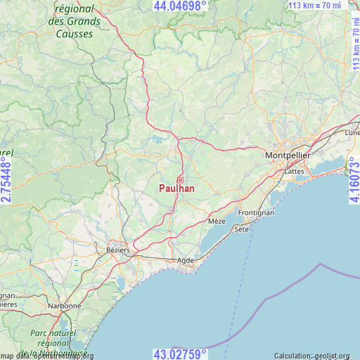
Paulhan GPS coordinates[2]
43° 32' 21.984" North, 3° 27' 27.36" East
| Map corner | latitude | longitude |
|---|---|---|
| Upper-left | 44.04698°, | 2.75448° |
| Center: | 43.53944°, | 3.4576° |
| Lower-right: | 43.02759°, | 4.16073° |
| Map W x H: | 113.3×113.3 km | = 70.4×70.4mi |
| max Lat: | 51.07786° ⇑92.6% North |
| Paulhan: | 43.53944° |
| min Lat: | ⇓7.4% South 41.3874° |
| min Long | Paulhan | max Long |
| -5.08615° | 3.4576° | 9.52242° |
| W 63.8%⇐ | ⇒36.2% E |
Elevation
Elevation of Paulhan is 44 m = 144 ft, and this is 149.7 m = 491 ft below average elevation for this country.
| Max E: |
2333 m = 7654 ft | 84.1% |
| Avg. | 193.7 m = 635 ft | |
| Paulhan | 44 m = 144 ft | |
Min E: |
-1 m = -3 ft | 15.9% |
See also: France elevation on elevation.city.
Geographical zone
Paulhan is located in North temperate zone (between Tropic of Cancer and the Arctic Circle). Distance of this Northern Tropic circle is 2235.2 km =1388.9 mi to South.| Distance of | km | miles | from Paulhan |
|---|---|---|---|
| North Pole | 5165.9 | 3209.9 | to North |
| Arctic Circle | 2560 | 1590.7 | to North |
| Tropic Cancer | 2235.2 | 1388.9 | to South |
| Equator | 4841.1 | 3008.1 | to South |


Nearby cities:
15 places around Paulhan: (largest is in red/bold)
• Adissan
2.6 km =1.6 mi,  256°
256°
• Aspiran
3 km =1.9 mi,  348°
348°
• Caux
8.2 km =5.1 mi,  243°
243°
• Fontès
6.3 km =3.9 mi,  270°
270°
• Le Pouget
7.9 km =4.9 mi,  42°
42°
• Lézignan-la-Cèbe
5.4 km =3.4 mi,  198°
198°
• Montagnac
6.8 km =4.2 mi,  162°
162°
• Nizas
4.9 km =3 mi,  234°
234°
• Nébian
7.8 km =4.8 mi,  344°
344°
• Plaissan
5.9 km =3.7 mi,  70°
70°
• Péret
6.3 km =3.9 mi,  309°
309°
• Pézenas
9.3 km =5.8 mi, 197°
• Saint-Pargoire
5.1 km =3.2 mi,  104°
104°
• Saint-Pons-de-Mauchiens
5.5 km =3.4 mi,  122°
122°
• Vendémian
9.6 km =6 mi,  61°
61°
Sources, notices
• [Note1] Compared only with cities in France existing in our database
• [Src1] Map data: © OpenStreetMap contributors (CC-BY-SA)
• [Src2] Other city data from geonames.org with taken over terms of usage.
• [Src3] Geographical zone / Annual Mean Temperature by Robert A. Rohde @ Wikipedia
