Champagney geodata
Champagney (Bourgogne-Franche-Comté) is a populated place; located in France in Europe/Paris (GMT+2) time zone. With population of 3,526 people, there are 2761 cities with bigger population in this country. Compared to other cities in France, 54.3% of cities are located further ↓South; 92.9% of cities are located further ←West and 86.5% of cities have lower elevation than Champagney. Note1
Administrative division(s):
- Level 1: Bourgogne-Franche-Comté
- Level 2: Département de la Haute-Saône
- Level 3: Arrondissement de Lure
- Level 4: Champagney


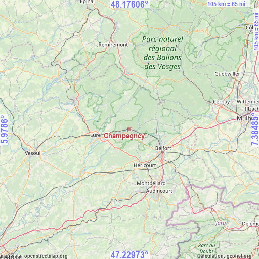
Champagney GPS coordinates[2]
47° 42' 18.144" North, 6° 40' 54.228" East
| Map corner | latitude | longitude |
|---|---|---|
| Upper-left | 48.17606°, | 5.9786° |
| Center: | 47.70504°, | 6.68173° |
| Lower-right: | 47.22973°, | 7.38485° |
| Map W x H: | 105.2×105.2 km | = 65.4×65.4mi |
| max Lat: | 51.07786° ⇑45.7% North |
| Champagney: | 47.70504° |
| min Lat: | ⇓54.3% South 41.3874° |
| min Long | Champagney | max Long |
| -5.08615° | 6.68173° | 9.52242° |
| W 92.9%⇐ | ⇒7.1% E |
Elevation
Elevation of Champagney is 367 m = 1204 ft, and this is 173.3 m = 569 ft above average elevation for this country.
| Max E: |
2333 m = 7654 ft | 13.5% |
| Champagney | 367 m 1204 ft | |
| Avg. | 193.7 m = 635 ft | |
Min E: |
-1 m = -3 ft | 86.5% |
See also: France elevation on elevation.city.
Geographical zone
Champagney is located in North temperate zone (between Tropic of Cancer and the Arctic Circle). Distance of this North polar circle is 2096.9 km =1303 mi to North.| Distance of | km | miles | from Champagney |
|---|---|---|---|
| North Pole | 4702.8 | 2922.2 | to North |
| Arctic Circle | 2096.9 | 1303 | to North |
| Tropic Cancer | 2698.4 | 1676.7 | to South |
| Equator | 5304.3 | 3295.9 | to South |


Nearby cities:
15 places around Champagney: (largest is in red/bold)
• Chagey
11 km =6.8 mi,  159°
159°
• Chenebier
7.4 km =4.6 mi, 157°
• Châlonvillars
10.5 km =6.5 mi,  133°
133°
• Frahier-et-Chatebier
6.7 km =4.2 mi, 129°
• Fresse
7.4 km =4.6 mi,  330°
330°
• Frotey-lès-Lure
11.1 km =6.9 mi,  240°
240°
• La Côte
8.4 km =5.2 mi,  256°
256°
• Lachapelle-sous-Chaux
10.4 km =6.5 mi,  90°
90°
• Mélisey
9.2 km =5.7 mi,  304°
304°
• Plancher-Bas
4 km =2.5 mi,  65°
65°
• Plancher-les-Mines
7.8 km =4.8 mi,  36°
36°
• Ronchamp
3.5 km =2.2 mi, 261°
• Saint-Barthélemy
8.9 km =5.5 mi, 304°
• Salbert
10.6 km =6.6 mi,  111°
111°
• Ternuay-Melay-et-Saint-Hilaire
9.7 km =6 mi,  337°
337°
Sources, notices
• [Note1] Compared only with cities in France existing in our database
• [Src1] Map data: © OpenStreetMap contributors (CC-BY-SA)
• [Src2] Other city data from geonames.org with taken over terms of usage.
• [Src3] Geographical zone / Annual Mean Temperature by Robert A. Rohde @ Wikipedia
