Fresse geodata
Fresse (Bourgogne-Franche-Comté) is a populated place; located in France in Europe/Paris (GMT+2) time zone. With population of 649 people, there are 12531 cities with bigger population in this country. Compared to other cities in France, 55.2% of cities are located further ↓South; 92.5% of cities are located further ←West and 89.3% of cities have lower elevation than Fresse. Note1
Administrative division(s):
- Level 1: Bourgogne-Franche-Comté
- Level 2: Département de la Haute-Saône
- Level 3: Arrondissement de Lure
- Level 4: Fresse


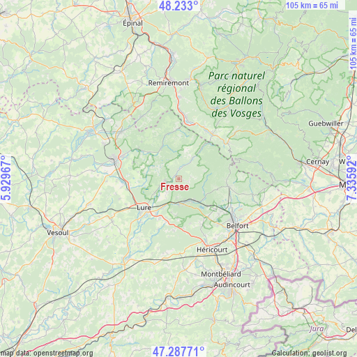
Fresse GPS coordinates[2]
47° 45' 45" North, 6° 37' 58.044" East
| Map corner | latitude | longitude |
|---|---|---|
| Upper-left | 48.233°, | 5.92967° |
| Center: | 47.7625°, | 6.63279° |
| Lower-right: | 47.28771°, | 7.33592° |
| Map W x H: | 105.1×105.1 km | = 65.3×65.3mi |
| max Lat: | 51.07786° ⇑44.8% North |
| Fresse: | 47.7625° |
| min Lat: | ⇓55.2% South 41.3874° |
| min Long | Fresse | max Long |
| -5.08615° | 6.63279° | 9.52242° |
| W 92.5%⇐ | ⇒7.5% E |
Elevation
Elevation of Fresse is 413 m = 1355 ft, and this is 219.3 m = 719 ft above average elevation for this country.
| Max E: |
2333 m = 7654 ft | 10.7% |
| Fresse | 413 m 1355 ft | |
| Avg. | 193.7 m = 635 ft | |
Min E: |
-1 m = -3 ft | 89.3% |
See also: France elevation on elevation.city.
Geographical zone
Fresse is located in North temperate zone (between Tropic of Cancer and the Arctic Circle). Distance of this North polar circle is 2090.5 km =1299 mi to North.| Distance of | km | miles | from Fresse |
|---|---|---|---|
| North Pole | 4696.4 | 2918.2 | to North |
| Arctic Circle | 2090.5 | 1299 | to North |
| Tropic Cancer | 2704.8 | 1680.7 | to South |
| Equator | 5310.7 | 3299.9 | to South |


Nearby cities:
15 places around Fresse: (largest is in red/bold)
• Champagney
7.4 km =4.6 mi,  150°
150°
• Faucogney-et-la-Mer
10.2 km =6.3 mi,  329°
329°
• Frotey-lès-Lure
13.3 km =8.3 mi,  206°
206°
• La Côte
9.5 km =5.9 mi, 208°
• Lepuix
13.6 km =8.5 mi,  90°
90°
• Lure
13.5 km =8.4 mi,  229°
229°
• Mélisey
4.1 km =2.5 mi,  253°
253°
• Plancher-Bas
8.7 km =5.4 mi,  123°
123°
• Plancher-les-Mines
8.2 km =5.1 mi, 90°
• Ronchamp
6.9 km =4.3 mi,  178°
178°
• Roye
12.4 km =7.7 mi, 213°
• Saint-Barthélemy
3.9 km =2.4 mi, 249°
• Saint-Germain
8.7 km =5.4 mi,  241°
241°
• Servance
6.9 km =4.3 mi,  33°
33°
• Ternuay-Melay-et-Saint-Hilaire
2.6 km =1.6 mi,  359°
359°
Sources, notices
• [Note1] Compared only with cities in France existing in our database
• [Src1] Map data: © OpenStreetMap contributors (CC-BY-SA)
• [Src2] Other city data from geonames.org with taken over terms of usage.
• [Src3] Geographical zone / Annual Mean Temperature by Robert A. Rohde @ Wikipedia
