Saint-Avé geodata
Saint-Avé (Brittany) is a populated place; located in France in Europe/Paris (GMT+2) time zone. With population of 8,907 people, there are 1079 cities with bigger population in this country. Compared to other cities in France, 54.1% of cities are located further ↓South; 96.7% of cities are located further →East and 78.6% of cities have higher elevation than Saint-Avé. Note1
Administrative division(s):
- Level 1: Brittany
- Level 2: Morbihan
- Level 3: Arrondissement de Vannes
- Level 4: Saint-Avé


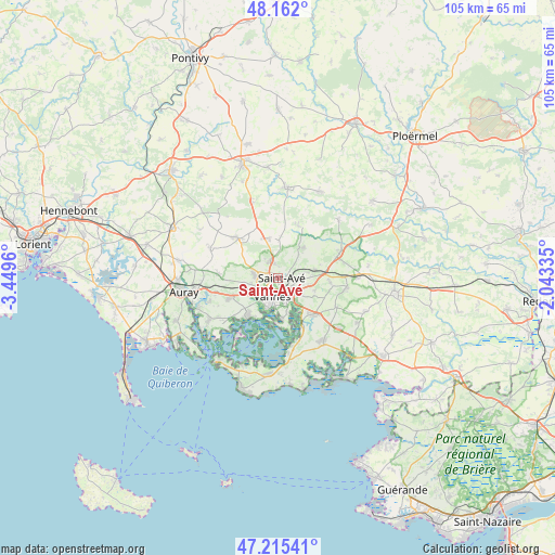
Saint-Avé GPS coordinates[2]
47° 41' 27.06" North, 2° 44' 47.328" West
| Map corner | latitude | longitude |
|---|---|---|
| Upper-left | 48.162°, | -3.4496° |
| Center: | 47.69085°, | -2.74648° |
| Lower-right: | 47.21541°, | -2.04335° |
| Map W x H: | 105.3×105.2 km | = 65.4×65.4mi |
| max Lat: | 51.07786° ⇑45.9% North |
| Saint-Avé: | 47.69085° |
| min Lat: | ⇓54.1% South 41.3874° |
| min Long | Saint-Avé | max Long |
| -5.08615° | -2.74648° | 9.52242° |
| W 3.3%⇐ | ⇒96.7% E |
Elevation
Elevation of Saint-Avé is 58 m = 190 ft, and this is 135.7 m = 445 ft below average elevation for this country.
| Max E: |
2333 m = 7654 ft | 78.6% |
| Avg. | 193.7 m = 635 ft | |
| Saint-Avé | 58 m = 190 ft | |
Min E: |
-1 m = -3 ft | 21.4% |
See also: France elevation on elevation.city.
Geographical zone
Saint-Avé is located in North temperate zone (between Tropic of Cancer and the Arctic Circle). Distance of this North polar circle is 2098.4 km =1303.9 mi to North.| Distance of | km | miles | from Saint-Avé |
|---|---|---|---|
| North Pole | 4704.3 | 2923.1 | to North |
| Arctic Circle | 2098.4 | 1303.9 | to North |
| Tropic Cancer | 2696.8 | 1675.7 | to South |
| Equator | 5302.7 | 3294.9 | to South |


Nearby cities:
15 places around Saint-Avé: (largest is in red/bold)
• Arradon
9 km =5.6 mi,  218°
218°
• Grand-Champ
10.6 km =6.6 mi,  315°
315°
• Le Hézo
12.2 km =7.6 mi,  164°
164°
• Locmaria-Grand-Champ
7.9 km =4.9 mi,  337°
337°
• Meucon
3.1 km =1.9 mi, 338°
• Monterblanc
7.6 km =4.7 mi,  41°
41°
• Noyalo
10.4 km =6.5 mi,  150°
150°
• Plaudren
10.5 km =6.5 mi,  22°
22°
• Plescop
4.5 km =2.8 mi,  279°
279°
• Ploeren
9.6 km =6 mi,  246°
246°
• Saint-Nolff
7.2 km =4.5 mi,  78°
78°
• Séné
8 km =5 mi,  174°
174°
• Theix
9.9 km =6.2 mi,  134°
134°
• Treffléan
10.1 km =6.3 mi,  95°
95°
• Vannes
3.7 km =2.3 mi,  190°
190°
Sources, notices
• [Note1] Compared only with cities in France existing in our database
• [Src1] Map data: © OpenStreetMap contributors (CC-BY-SA)
• [Src2] Other city data from geonames.org with taken over terms of usage.
• [Src3] Geographical zone / Annual Mean Temperature by Robert A. Rohde @ Wikipedia
